Guildford
The exact location of the main Anglo-Saxon settlement is unclear and the current site of the modern town centre may not have been occupied until the early 11th century.
During the late Middle Ages, Guildford prospered as a result of the wool trade, and the town was granted a charter of incorporation by Henry VII in 1488.
The River Wey Navigation between Guildford and the Thames was opened in 1653, facilitating the transport of produce, building materials and manufactured items to new markets in London.
Guildford is surrounded on three sides by the Surrey Hills National Landscape, which severely limits its potential for expansion to the east, west and south.
[4] The first part of the name is thought to derive from the Old English gylde, meaning gold,[5] possibly referring to the colour of the sand to the south of the town, or to a local concentration of yellow flowers such as the common or marsh marigold.
Contemporary accounts are somewhat contradictory, but the modern consensus is that Aetheling, a pretender to the throne and the brother of Edward the Confessor, was travelling through Guildford with a large bodyguard when the incident occurred.
[25] There is no significant archaeological evidence of human activity in the modern town centre before the 11th century[26][27] and it is possible that, for the majority of the Saxon period, Stoke next Guildford, to the north, was the primary area of settlement.
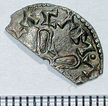
[36] Henry VII was responsible for granting Guildford its coat of arms in 1485 and, three years later, he awarded the charter of incorporation, which placed the administration of the borough in the hands of a mayor and burgesses, appointed from the merchants' guild.
[38] A year later, the Guildford Poor Law Union was formed, with responsibility for a total area of 12 sq mi (31 km2) stretching from Godalming to Woking.
[38][40][note 8] The final enlargement took place in March 1974, when the present local authority was created from the merger of the borough with the Guildford Rural District.
Excavations in the 1970s revealed that the original buildings were arranged around three sides of a central cloister, with a church to the south, chapter house to the east and kitchen to the north.
[58] In 1858, the Chennel family set up a steam-powered flour mill on the site of the friary church and cloisters, which was subsequently purchased and converted to a brewery by Thomas Taunton in the 1870s.
By the end of the 17th century, timber was being transported via the river from the county boundary with West Sussex[74] and in 1724, Daniel Defoe wrote that corn from Farnham was being sent by barge to London.
[80][81] Woking railway station,[note 15] was built on the south side of the tracks for the convenience of those travelling by stagecoach from Guildford and quickly became the railhead for the western half of the county.
[86] The trade began to decline at the end of the Tudor period, possibly as a result of fraudulent activity on the part of the wool merchants, who were accused of stretching the cloth.
[92] After the death of their father in 1882, brothers Charles Arthur and Leonard Gates took over the running of his shop, which held the local distribution franchise for Gilbey's wines and spirits, and also sold beer.
[104] The defence of the town was the responsibility of the 4th Battalion of Surrey Home Guard[105] and defensive installations included dragon's teeth close to London Road station, numerous pillboxes and an anti-tank ditch that was dug across Stoke Park.
To the north of Slyfield is Stoke Hill, on top of which is a park, Stringer's Common, across which is the Jacobs Well neighbourhood which is part of Worplesdon civil parish.
Parts of Onslow Village have been designated as conservation areas,[145] enforcing a number of planning restrictions that are intended to protect the character and identity of the locality.
The Onslow arboretum is located right next to the recreation area which has its own park, a large field, several tennis courts, toilets and a scout hut.
In 1701, William Yarnold received a grant from the borough corporation to erect a waterwheel and pumps to raise river water to a reservoir at the foot of Pewley Down.
[179] The current sewage works date from the 1960s, but will be relocated to a site 1.5 km (0.93 mi) to the north, as part of the Slyfield Area Regeneration Project.
[179][205] Initially the horse-drawn fire engine was housed in a shed in North Street,[205] but a brick building (now the public toilets) was built in the same road in 1872[206] The Guildford Brigade merged with others in Surrey in 1947, when the service became the responsibility of the county council.
[210] Supported by private donations, it provided free medical care to the poor, including a home visiting service and an out-patients clinic.
It is managed by South Western Railway, which operates most services; their routes run to London Waterloo via Clapham Junction, to Portsmouth Harbour via Godalming and Haslemere, and to Alton via Farnham.
In The Hitchhiker's Guide to the Galaxy by Douglas Adams, the character Ford Prefect, actually an alien from Betelgeuse, claims to be an out-of-work actor from Guildford.
Guildford Shakespeare Company performs in the town, using the bandstand in the castle grounds as the stage in the summer and several churches close to the High Street through the winter.
[311][note 34] It was not intended as a place for healing the sick, but instead provided accommodation for single people (initially 12 male and eight female), who had either been born in Guildford or who had lived there at least 20 years.
[324] In 2022, the institute offers a wide range of courses, a lending library and archive, a vegan restaurant and aims to provide an educational, cultural and social hub for the local community.
[329] The guild in Guildford was formed in the late 14th century shortly after 1366, when Edward III issued the fee farm grant, enabling the town to become self-governing in exchange for a yearly rent of £10.