Hastings Park
Its name references the Hastings Townsite, part of which was also known as New Brighton, which lay at the end of the Douglas Road from New Westminster, founded as a resort and watering-hole and as a port to connect the other settlements of the inlet—Gastown, Moodyville and Barnet—to the city.
The land was originally granted in trust to the City by the Province in 1888 as part of the will of its late owner, with the site to be kept in perpetuity as wilderness park for public use.
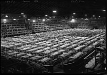
Following Canada's declaration of war on Imperial Japan in 1942, Hastings Park was used to house and process Japanese Canadians before being sent to internment camps in the interior of British Columbia.
[1] Over time PNE facilities grew in the post-war period by the addition of the BC Building, housing the once-famous Challenger Relief Map of British Columbia and the Agrodome, plus the regular expansion of buildings and structures in Playland, most visibly its roller coaster, prominent on the eastern approach into the city via Hastings Street and via Highway 1, but also a vintage games arcade and electric bumper-car "rink".
[2] This project, which completed its first stage in September 2013, also includes new pedestrian and bicycle pathways between the two parks as well as providing an ecological corridor to the Burrard Inlet.