U.S. Route 99 in California
US 99 continued along present-day SR 111 through Coachella to its intersection at Dillon Road with another major US route signed as both US 60 and US 70.
Now signed as US 60/US 70/US 99, the highway continued north through Indio and turned west through the San Gorgonio Pass toward Los Angeles paralleling the route of modern I-10.
[citation needed] Prior to the construction of the superhighway, US 99 entered Los Angeles on Valley Boulevard, multiplexed with US 70.
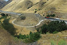
US 99's original alignment over the rugged Tehachapi Mountains was known in its earliest days as the Ridge Route, the first highway directly linking the Los Angeles Basin to the San Joaquin Valley.
Built in 1915, the alignment between Castaic and SR 138 to Gorman is listed on the National Register of Historic Places.
Dropping down from the Tehachapis, US 99 entered the San Joaquin Valley at the bottom of the steep Grapevine grade (the foot of the Tejon Pass) and continued north.
From 1937 to 1964 it shared this routing with US 6; the remaining stretch of the highway through the Santa Clarita Valley is named "The Old Road".
The Old Road starts near the Newhall Pass Interchange, just south of Santa Clarita, eventually crossing under present-day I-5.
The Sacramento River Canyon was a big task to overcome, but to this day, many bridges can still be found and visited, reminding us of how far our engineering has come.
Once into Siskiyou County, the highway meanders through Dunsmuir, heading north to Mount Shasta, and from there, up to Weed.
Sections were expanded to four lanes starting in the late 1930s and by 1961 Los Angeles to Sacramento was all four-lane, much of it being full freeway.
By 1968, US 99 was decommissioned with the completion of I-5 in Washington and California, but the highway's phasing out actually began July 1, 1964, thanks to the passage of Collier Senate Bill No.
The bill launched a program to simplify California's complicated highway numbering system and eliminate concurrent postings like the aforementioned US 60/US 70/US 99.
U.S. Route 99W was a short-lived alternate of US 99 in the Central Valley of California, running from north of Manteca via French Camp to Stockton.
At French Camp, pre-1964 Legislative Route 5 split to the southwest to reach the San Francisco Bay Area via Altamont Pass.