History of Aubing
The earliest evidence of human habitation in the Aubing Gemarkung was discovered in 1995/1996, situated to the south of Bodenseestraße (Bundesstraße 2) within the Freiham development area.
Subsequently, burial finds of the early Urnfield Culture[1] were discovered, as they also came to light in the wider area, for example in 2005 in a well under the Aubinger Weg in the form of a clay temple.
[4] In 2010, findings from the Corded Ware period were also unearthed to the north of Bodenseestraße, east of Freihamer Weg, during pre-construction investigations conducted by the State Office for the Preservation of Monuments.
A stool burial of an adult male in a supine position with bent arms and legs was discovered in a circular ditch measuring six and a half meters in diameter.
[7] The oldest surviving documented mention of Ubingun is a deed from King Henry II dated April 16, 1010, which was sealed in the Reich Chancellery in Regensburg.
In addition to Aubing, the restitution affected the villages of Polling, Weilheim, Rieden, Landstetten, Aschering and Wangen, all situated to the west and north of Lake Starnberg, as well as a Pfaffenhofen, presumably Oberpfaffenhofen.
[8][11] To obtain an overview of their estates, the Wittelsbach dukes had their chancellery in Landshut draw up Urbarium, lists of the property and rights of the duchy, which had evidential value, similar to today's land registrations.
The Latin document indicates that this also included "Tota villa in Awbingen cum omnibus suis pertinentiis ...," which translates to the entire village of Aubing with all its appurtenances.
In the case of "Tota villa," or the entire village, it is important to note that approximately one-quarter of the Aubing farms were under the ownership of other lords and therefore did not transfer to the Ettal Abbey.
The tithing rights of Polling Abbey and the religious assignment of the parish of Aubing to the diocese of Freising remained unaffected by the donation to Ettal.
There are no eyewitness accounts from Aubing, but a list from the Ettal Abbey from 1637 and a tax book from the Dachau district court from 1670 indicate that at least 19 farms were destroyed by fire.
In addition to the Ettal Abbey and the Dachau district court, the parish of St. Quirin in Aubing was the third most influential local authority in the Middle Ages and early modern period.
For example, Michael Gotzmann served as vicar (deputy) to Stephan Sundersdorfer, a Freising canon, who documented the financial and personal circumstances of the parish in a register from 1524.
"[31] Theander had studied in Vienna and brought back an early mathematical text from there in 1537, which today belongs to the collection of the Austrian National Library as part of the manuscript CVP 5277.
In the only rectory, the privy is next to the kitchen and the cesspool goes under the house.During his visit to Aubing, Pettenkofer, with the help of Pastor Gigl, first reconstructed exactly when and where the cholera cases had occurred.
Pettenkofer discussed the possibility that the risk of infection depended on the amount of public traffic, but rejected this because there were no cases in the house of the local headman, the vicarage, or the inn.
He concluded: Aubing is therefore also a clear demonstration that personal contact alone is not sufficient for the development of an epidemic, however necessary it may be, and that other factors must also be involved, one of which is the local situation.Although he suggested elsewhere in his presentation that the influence of groundwater levels was likely, he did not discuss the possibility of a pathogen being carried in the water.
The line, built along the route of an originally planned canal, passed directly south of the town's buildings at that time; the Aubing station was not far from the parish church of St. Quirin.
Living in Aubing was cheap compared to the royal residence city of Munich and therefore popular with middle-income earners so that a lot of building land changed hands.
Alongside Dornier, the large repair plant was the most important local employer for generations and helped shape the culture of life in Aubing in the 20th century.
At the end of the 1960s, the railroad was already considering the dissolution of the repair works, but in 1969 those responsible decided to keep it in a reduced form, which would bring economic advantages for the location in the course of modernization and reorganization.
For the workers and officials of the Central Workshop, the first housing estate was built on today's Papinstraße, south of the new railroad line and two kilometers from Alt-Aubing, the so-called colony.
The necessary expenditures were such a burden on the community that in 1914 the local council applied for incorporation into the financially strong neighboring town of Pasing, which had by then been elevated to the status of a city.
[44][50] A few years later, during the Second World War, the barracks of the Neuaubing forced labor camp, which still exists today, were built directly west of the Dornier estate.
A simple building, plastered white, with a steep hip roof, the porch supported by four columns, green shutters, and trellis cladding on the side fronts; so the house is sunny rather than sad- which was the intention.
The deterioration of the supply situation due to the trade blockades against the German Reich led to the rationing of all raw materials and food in the community.
[43] After the November Revolution of 1918 and the proclamation of the "Free People's State of Bavaria" by Kurt Eisner, an 18-member workers' and peasants' council first demanded the resignation of the mayor and the municipal committee in January 1919.
As far as can be ascertained, they were imprisoned for In the summer of 1933, Neuaubing union secretary and Reichsbanner leader Josef Lampersberger was a courier for the Sopade, the exiled executive of the SPD in Czechoslovakia.
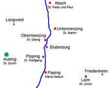
Riem was incorporated in 1936, followed by Feldmoching, Allach, Untermenzing, Obermenzing, Großhadern, Solln, and Pasing in 1938, making Munich and Aubing neighboring communities.
[43] In 1943/44, bombs fell on the Reichsbahn repair shop, the Dornier factory, an anti-aircraft position in the area of today's Neuaubing-West housing development, and an electrical substation in the Aubinger Lohe, causing extensive damage.