History of Auckland
[2] From early occupation until European contact, the economy of the region was centred around horticulture (mostly root vegetables such as kūmara (sweet potato)), fishing and shellfish gathering.
Other Tainui descendants were Te Kawerau ā Maki, who lived under forest cover in the Waitākere Ranges and controlled land as far north as the Kaipara, across to Mahurangi and down to Takapuna.
Between 1740 and 1750 Ngāti Whātua-o-Kaipara moved south, invading the isthmus and killing Kiwi Tāmaki, paramount chief of Waiohua.
European settlement to the north enabled traditional rivals Ngāpuhi and allied northern iwi to acquire muskets by trade.
Soon after signing Te Tiriti, Ngāti Whātua Ōrākei, the primary hapū and landowner in Tāmaki Makaurau, made a tuku (strategic gift) of 3,500 acres (1,400 hectares) of land on the Waitematā Harbour to Hobson, the new Governor of New Zealand, for the new capital.
[15][16] After the signing of the Treaty of Waitangi in February 1840 the new Governor of New Zealand, William Hobson, had the task of choosing a capital for the colony.
Auckland was officially declared New Zealand's capital in 1841,[17] and the transfer of the administration from Russell in the Bay of Islands was completed in 1842.
[citation needed] On the initial recommendation of the missionary Henry Williams, supported by the Surveyor General, Felton Mathew, and the offer of land from Ngāti Whātua, Hobson selected the south side of Waitematā Harbour as his future capital, while setting up a temporary capital at Okiato (also known now as Old Russell) in the Bay of Islands.
[citation needed] Ngāti Whātua would certainly have expected from British colonialism increased security and trading benefits.
This would include greater access via the quickly developed port facilities for the lucrative trade in produce grown in Tainui's fertile Waikato and Hauraki Plains for the Australian prison colonies and Sydney market.
[citation needed] A foundation ceremony took place on 18 September 1840, at Point Britomart (Rerenga Ora Iti).
[citation needed] From the late 1840s, settlers attending Anglican chapels built in the then-rural communities of Tāmaki, Epsom and Remuera were ministered to by the staff and students of St John's Theological College which was established in 1843.
Between 1847 and 1852 large numbers of retired British soldiers, called fencibles, and their families came to Auckland to create a ring of outlying villages to protect the capital.
In addition in 1849 Grey sold land in Māngere to the leading Māori chief Te Wherowhero and 149 members of the Ngāti Mahuta tribe from Tamahere in the Waikato.
The reason for the attack was the arrest of a Ngāti Pāoa chief for stealing a shift at a Shortland Street shop.
[26][22] St Stephen's Anglican School (initially educating Māori girls, then later boys) opened in Kohimarama in 1847 then moved to Parnell in 1850.
The last Lieutenant-Governor of New Ulster, Robert Wynyard, became the first superintendent of Auckland Province following the 1853 New Zealand provincial elections.
This was largely due to it continuing to be a major port and in particular, the location of the Devonport Naval Base; both the 1902 Royal Tour and especially the 1908 visit by the American Fleet underscored this status.
[citation needed] Auckland formed a base for Governor George Grey's operations against the Māori King Movement in the early 1860s.
Market gardens were planted on the outskirts, while kauri tree logging and gum digging, mainly by Thomas Henderson, opened up the Waitākere Ranges.
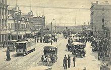
[citation needed] Throughout the 19th century Auckland's intense urban growth concentrated around the port in a very similar manner to most other mercantile cities.
[citation needed] A Russian scare at the end of the 19th century had caused coastal guns to be bought and fortifications built, notably at North Head and on Waiheke Island, where they can still be seen.
[citation needed] In World War II the city was overflown by a Japanese seaplane, chased ineffectually by a Royal New Zealand Air Force De Havilland Tiger Moth.
Again, coastal fortifications were built or extended, with a large military base on Rangitoto Island storing mines supposed to block the inner Hauraki Gulf in the event of an impending Japanese invasion, which never eventuated.
Just before midnight NZST on 10 July 1985, two explosive devices attached to the hull by operatives of the French intelligence service (DGSE) were detonated, creating a gaping hole in the side of the vessel.
[citation needed] In 1993, the Police Eagle helicopter and a traffic-spotting plane collided in mid-air, falling to the packed motorway below during Friday night rush hour.
While the blackout lasted only about half a day, it reignited political pressure aiming to improve the national electricity grid.