Auckland CBD
It is the area in which Auckland was established in 1840, by William Hobson on land gifted by mana whenua hapū Ngāti Whātua Ōrākei.
It is New Zealand's leading financial hub, and the centre of the country's economy; the GDP of the Auckland Region was NZD$139 billion in the year ending September 2023.
The CBD is generally considered to be bounded by the main motorways that surround all non-harbour sides, with State Highway 1 forming the southern and western boundaries, and State Highway 16 / Grafton Gully forming the eastern boundary.
On 20 March 1840, paramount chief of the Ngāti Whātua Māori iwi (tribe) of Auckland Apihai Te Kawau, signed the Treaty of Waitangi.
[7] Ngāti Whātua sought British protection from Ngāpuhi as well as a reciprocal relationship with the Crown and the Church.
Soon after signing the treaty, Ngāti Whātua Ōrākei made a strategic gift of 3,500 acres (1,400 ha) of land on the Waitematā Harbour to the new Governor of New Zealand, William Hobson, for the new capital, which Hobson named for George Eden, Earl of Auckland, then Viceroy of India.
[11][12] The town of Auckland was created in 1840 with the first European colonisation of the area, marked by an official ceremony on the now non-existent Point Britomart.
The initial centre of the new town was focused on what is now the corner of Shortland and Queen Street, which was at the shoreline of Commercial Bay.
From approximately their junction, the main wharf ran north off the end of Queen Street, with Shortland Street leading up to St Paul's Church, Fort Britomart and Government House, around which many of the richer people built houses.
The 1850s onwards saw an increasing number of businesses, and especially retail, locating further south along Queen Street, which still to this day forms the 'spine' of the area.
Up until the middle of the 20th century the centre of town still contained a large number of small factories including clothing manufacturers.
[citation needed] The relocation of industries to outlying suburbs became especially pronounced in the 1950s, partly due to incentives made by council planners to create industrial areas in Penrose and Rosebank Road (amongst others) and thus rid the inner city area of noise, pollution and heavy traffic.
Attempts by the council to halt this pattern by constructing numerous public car parking buildings met with varying success.
In the two-mile zone surrounding the CBD, there were approximately 70,000 people in 1926, with only around 50,000 in 1966 – a change made even more marked by the development of the remainder of Auckland's population, which grew more than fourfold in the same timeframe.
[15] In the 1990s, only a token population of around 1,400 was still residing within the CBD, though this was to grow substantially with a boom of new apartment buildings around the turn of the millennium.
The area of today's CBD was the site of the original European settlement of Auckland, oriented along the coastline and then Queen Street, in a southward direction.
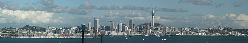
From those origins, it has grown progressively, and become much more densely built-up, now being an area of high-rise buildings mainly used for commercial and retail uses.
[21] The area east of the Waitematā railway station is currently undergoing major changes, with the development of new commercial buildings, the restoration of several heritage buildings and development of public spaces, including a new public square named Te Komititanga which opened in 2020.
[23] Another major regeneration scheme currently underway is the redevelopment of Wynyard Quarter, which involves replacing industrial facilities covering a large portion of the CBD waterfront with residential or commercial buildings and public spaces.
[25] Residential high-density buildings constructed since the 1990s have helped to substantially increase the population living in the CBD.
During the same year, an Auckland City report stated that the Auckland CBD, compared to several central business districts in Australia, had "a broader and more dominant role in its regional economy" compared to the economies of the Australian central business districts.
In 2006, from late September to early October, the airline moved employees out of the four buildings it occupied in Auckland CBD and relocated them to the new headquarters in the Wynyard Quarter.
In 2009, the former Auckland City Council proposed the redevelopment of several CBD streets into shared spaces, with the goal of improving pedestrian and cyclist amenity by slowing down vehicle traffic while retaining the possibility for car access – compared to a pedestrian mall which allows no motor vehicles.