History of Hobart
[2] The first European settlement in the Hobart area began in 1803 as a penal colony and defensive outpost[3] at Risdon Cove on the eastern shores of the Derwent River, amid British concerns over the presence of French explorers in the South Pacific.
The early 20th century saw another period of growth on the back of mining, agriculture and other primary industries, but the world wars had a very negative effect on Hobart, with a severe loss of working age men.
George Augustus Robinson's efforts to resettle them at Flinders Island resulted in the extermination of all the full-blooded native peoples by introduced European diseases such as smallpox, influenza and pneumonia.
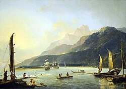
An expedition in 1802 to survey Van Diemen's Land by French explorers Nicolas Baudin and Louis de Freycinet aboard Géographe, Casuarina, and Naturaliste, stopped in the Derwent River to make observations of the indigenous Tasmanians, and the native flora and fauna.
[5] At the same time David Collins had been dispatched from London in response to King's initial request, and departed from England in April 1803, in command of HMS Calcutta with orders to establish a colony at Port Phillip.
[19] In January 1807, Lieutenant Thomas Laycock carried dispatches on horseback from Launceston to Hobart Town overland, taking eight days to traverse the island, and he became the first European to make that journey through the interior.
[22] Eleanor Casella argues that the design of the female factories were predicated on the thought that convict women could be morally reformed through the prescription of manual labour, thus these institutions were essentially turned into economically productive, government supervised “manufactories”.
[26] After women had served their sentences, or after periods of nominal good behaviour, they were promoted to a “hiring class” which meant that they were ready to be employed within domestic service, often on farmland, within the hospital or a role within the prison itself.
[29] Casella maintains that contrary to traditional portrayals of these women as “a monolithic bunch of damned whores,” most of them were convicted of petty crime, serving sentences of seven to fourteen years.
The settlement was plagued with problems such as a shoddy workforce (mostly unskilled convict labour, and unwilling Marines pressed into work duties), insufficient supplies and neglect by imperial authorities, disease and constant threat of Aboriginal attack, difficult terrain, and quarrels amongst settlers.
However, after a long hot summer between December 1803 and February 1804, during which the Risdon Cove encampment received not a single day of rain whatsoever, the creek was dried up completely and the grass and woodlands parched.
Surveyor George Harris was dispatched in a longboat, and within a day had reported back to Collins that he had located an excellent sheltered cove at the mouth of a fast flowing stream that seemed fed by the melted snow off Table Mountain (now Mount Wellington).
Expected supply ships did not arrive in the first year, and the lack of cultivation of wheat that was essential for survival, combined with bad droughts and soaring temperatures in the summers of 1805 and 1806 nearly ended the colony.
Unlike Sydney, where harsh summer conditions made the first attempts at agriculture difficult, Hobart Town's crops in 1806 and 1807 were so successful there was a large surplus of wheat and produce.
[37] Although both exploration and settlement were hampered by the island's mountainous topography, the colony soon established itself, and local food production replaced a dependency on external supply, and settlers began to better exploit the area's natural resources.
Governor Lachlan Macquarie toured the Hobart Town settlement in 1811, not long after his appointment in New South Wales, and his suppression of the Rum Rebellion, whilst he was still brimming with energy and confidence.
Degreaves relocated the brewery to the site of an old sawmill, slightly further upstream along the Hobart Rivulet, and a further three storeys were added to the main building in 1927, creating the iconic structure that survives to this day.
He writes of Hobart Town and the Derwent estuary in his Voyage of the Beagle: ...The lower parts of the hills which skirt the bay are cleared; and the bright yellow fields of corn, and dark green ones of potatoes, appear very luxuriant...
The town was in danger of losing trade from Royal Navy vessels due to the large number of sailors contracting venereal diseases whilst on shore leave in the port.
Lady Jane attempted to establish evening gatherings to discuss art, literature and science, but these proved unpopular with well-to-do 'Hobartians', who preferred that she host parties and dances instead.
[5] The middle of the century saw Hobart Town as a major southern trading port with excellent rates of growth, well known and regularly visited, attracting commerce and emigrants.
By the early 20th century, tramlines ran from the city depot to North Hobart, Lenah Valley, Springfield, Glenorchy, Cascade Brewery, Proctor's Road, and Sandy Bay.
In it he writes: How beautiful is the whole region, for form, and grouping, and opulence, and freshness of foliage, and variety of colour, and grace and shapeliness of the hills, the capes, the promontories; and then, the splendour of the sunlight, the dim, rich distances, the charm of the water-glimpses!
[5] The Cadbury Chocolate Factory project mirrored the company's Quaker principles of taking responsibility for bettering the lives of the workers, pioneered in their Bournville operation in the United Kingdom.
It had cost £26,000 and allowed easy access from the Springs, which soon became a tourism and day-trip destination, to the Summit, which although subject to volatile weather changes, has views over Hobart and the Derwent River estuary.
On 7 February 1967, a combination of high winds, a heat wave, ill-conceived back-burning and deliberate arson led to the worst outbreak of urban bushfire in Hobart's recorded history.
Despite the double boom in tourism in the 1950s and 1960s, Tasmania's geographic isolation deterred the craved foreign investment in industry that was needed to stimulate the economy, and the government was constantly dealing with economic fluctuations.
Whilst many ferry services were launched to try and aid commuters stranded by the disaster, others had to endure a 20 km round trip to the temporary bridge that was constructed near Risdon Cove.
The conservative Liberal government of Robin Gray had sought a third term in office, but had dramatically underestimated the widespread opposition to the construction of another paper pulp mill within the state, and the growing groundswell of support for the Tasmanian Greens party.
In 2008, widespread discussions commenced about the possible regeneration of large sections of Hobart's waterfront, particularly around Macquarie Point, and the old railyards near the docks to the north-eastern side of Sullivans Cove.