History of Malappuram district
Maritime contacts Sangam period Tamilakam Cheras Spice trade Ays Ezhil Malai Confluence of religionsMamankam festival Calicut Venad - Kingdom of QuilonValluvanad Kolattunadu CochinArakkal kingdom Minor principalities Age of Discovery Portuguese period Dutch period Rise of Travancore Mysorean invasion British PeriodBattle of TirurangadiMalabar DistrictNorth MalabarSouth Malabar Battle of Quilon Communism in KeralaLakshadweep Economy Architecture Malappuram is one of the 14 districts in the South Indian state of Kerala.
[3] Pliny the Elder (1st century CE) states that the port of Tyndis was located at the northwestern border of Keprobotos (Chera dynasty).
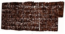
[11] Three Old Malayalam inscriptions those date back to 932 CE, those were found from Triprangode (near Tirunavaya), Kottakkal, and Chaliyar, mention the name of Goda Ravi of Chera dynasty.
[12] Several inscriptions written in Old Malayalam those date back to 10th century CE, have found from Sukapuram near Edappal, which was one of the 64 old Nambudiri villages of Kerala.
[2] A number of city-states were there in the region, including Valluvanad, Vettathunadu (Tanur), Parappanad and Nediyiruppu (Eranad) (ruled by the Zamorins).
Eranad was ruled by a Samanthan Nair clan known as Eradis, similar to the Vellodis of neighbouring Valluvanad and Nedungadis of Nedunganad.
The Eradis (A title used to denote the rulers of Eranad) of Nediyiruppu marched with their army to Panniyankara and often surrounded the headquarters of Porlathiri.
[17] Assisted by the warriors of their subordinate chiefs (Chaliyam, Beypore, Tanur and Kodungallur) and the Muslim naval fleet under the Koya of Kozhikode, the Samoothiri's fighters advanced by both land and sea.
Finally, two Valluvanadu princes were killed in the battles, the Nairs abandoned the settlement and Kozhikode infested Tirunavaya.
The Kizhakke Kovilakam Munalappadu, who took a leading part in this campaign, received half of the newly captured province from Samoothiri as a gift.
The ports of Ponnani, Tanur and Parappanangadi had some of the oldest Muslim settlements in Kerala originated as a result of the trade relationship.
[1] The works like Kozhikode Granthavari, Mamakam Kilippattu written by Kadanchery Namboodiri in 17th-century CE, Kandaru Menon Patappattu (1683), and Ramchcha Panicker Pattu contains pieces of information about the Mamankam festival held at the bank of Bharathappuzha in Tirunavaya.
[24] Thunchaththu Ezhuthachan, who is considered as the father of modern Malayalam literature, was born at Tirur (Vettathunadu) during Portuguese period.
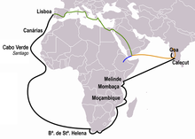
Towards the end of the year 1507, the Portuguese Viceroy Francisco de Almeida was informed that a column of 13 Muslim ships had taken cargo - mainly spices - from Ponnani and was about to leave for the Red Sea.
[19][28] The Zamorin appointed Kunjali Marakkar I, his loyal naval chief, in the port of Ponnani, to resist the Portuguese occupation.
[28] In 1523 when the Viceroy Menezes sailed with all the available ships to Hormuz, an Arab merchant, one Kutti Ali of Tanur, had the effrontery to bring a fleet of two hundred vessels to Calicut, to load eight ships with pepper, and to despatch them with a convoy of forty vessels to the Red Sea before the very eyes of the Portuguese.
In 1552, the Zamorin received assistance in heavy guns landed at Ponnani, brought by certain Yoosuf, a Turk, who had sailed against the monsoon winds.
[35] The Zamorin soon repented of having allowed this fort to be built in his dominions, and used ineffectual endeavours to induce the ruler of Parappanangadi, Caramanlii (King of Beypore?)
[31] It is also known that Gil Eanes Mascarenhas opened fire from his ships to the port and killed a large number of natives in 1582.
It is written in Arabic and contains pieces of information about the resistance put up by the navy of Kunjali Marakkar alongside the Zamorin of Calicut from 1498 to 1583 against Portuguese attempts to colonise Malabar coast.
[43] In 1792, Tipu Sultan was defeated by English East India Company through Third Anglo-Mysore War, and the Treaty of Seringapatam was agreed.
As per this treaty, most of the Malabar region, including present-day Malappuram district, was integrated into the English East India Company.
[42] The district was administered as parts of Eranad, Valluvanad and Ponnani subdistricts in the South Malabar region during the British rule.
It caused the leadership of the Malabar district Congress Committee to come under the control of the extremists who stood for labourers and the middle class.
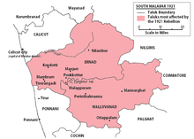
After the army, police, and British authorities fled, the declaration of independence took place over 200 villages in Eranad, Valluvanad, Ponnani, and Kozhikode taluks.
[52] On 25 August 1921, Variyankunnath Kunjahammad Haji inaugurated the Military Training Center at Angadipuram, which was started by the revolutionary government.
[55][56] Although the nation's lifespan is less than six months, some British officials have suggested that the region was ruled by a parallel government for more than a year.
In 1969, following intense demand from Indian Union Muslim League and various organizations the district of Malappuram was formed by the Saptakakshi Munnani government of Kerala.
[62] The new district was formed with four subdistricts (Eranad, Perinthalmanna, Tirur, and Ponnani), four towns, fourteen developmental blocks, and 95 Gram panchayats at the time.
They sent money home, supporting the rural economy, and by the late 20th century, the region attained First World health standards and near-universal literacy.