History of Kerala
Maritime contacts Sangam period Tamilakam Cheras Spice trade Ays Ezhil Malai Confluence of religionsMamankam festival Calicut Venad - Kingdom of QuilonValluvanad Kolattunadu CochinArakkal kingdom Minor principalities Age of Discovery Portuguese period Dutch period Rise of Travancore Mysorean invasion British PeriodBattle of TirurangadiMalabar DistrictNorth MalabarSouth Malabar Battle of Quilon Communism in KeralaLakshadweep Economy Architecture The term Kerala was first epigraphically recorded as Cheras (Keralaputra) in a 3rd-century BCE rock inscription by the Mauryan emperor Ashoka of Magadha.
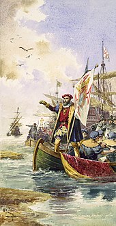
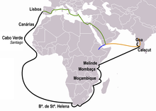
[6] In 1498, with the help of Gujarati merchants, Portuguese traveler Vasco Da Gama established a sea route to Kozhikode by sailing around the Cape of Good Hope, located in the southernmost region of Africa.
Onam is associated with the legendary king Mahabali (Maveli), who according to tradition and Puranas, ruled the Earth and several other planetary systems from Kerala.
[citation needed] The earliest Sanskrit text to mention Kerala by name as Cherapadah is the Aitareya Aranyaka, a late Vedic work on philosophy.
[31][34][35] The Eradis of Nediyiruppu, who later came to be known as the Zamorins of Kozhikode, who were left out in cold during allocation of the land, was granted the Cheraman Perumal's sword (with the permission to "die, and kill, and seize").
[49][55][56] Historian M. R. Raghava Varier of the Kerala state archaeology department identified a sign of "a man with jar cup" in the engravings, which is the most distinct motif of the Indus valley civilisation.
[60][61] The region around Coimbatore was ruled by the Cheras during Sangam period between c. 1st and the 4th centuries CE and it served as the eastern entrance to the Palakkad Gap, the principal trade route between the Malabar Coast and Tamil Nadu.
The Cheras were mentioned as Ketalaputo (Keralaputra) on an inscribed edict of emperor Ashoka of the Magadha Empire in the 3rd century BCE,[2] as Cerobothra by the Greek Periplus of the Erythraean Sea and as Celebothras in the Roman encyclopedia Natural History by Pliny the Elder.
[68] Megasthanes, the Greek ambassador to the court of Magadhan king Chandragupta Maurya (4th century BCE) mentions Muziris and a Pandyan trade centre.
The contact with Middle East and Romans might have given rise to small colonies of Jews, Syrian Christians and Mappila Muslims in the chief harbour towns of Kerala.
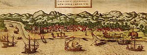
[104][105] The port at Kozhikode held the superior economic and political position in Kerala, while Kollam (Quilon), Kochi, and Kannur (Cannanore) were commercially confined to secondary roles.
[106] Adi Shankara (CE 789), one of the greatest Indian philosophers, is believed to be born in Kaladi in Kerala, and consolidated the doctrine of advaita vedānta.
Narayanan, an Indian historian, in his book, Calicut: The City of Truth states that the Eradi was a favourite of the last Later Chera king and granted him, as a mark of favor, a small tract of land on the sea-coast in addition to his hereditary possessions (Eralnadu province).
In the 14th century, Kozhikode conquered large parts of central Kerala following the seize of Tirunavaya from Valluvanad, which was under the control of the king of Perumbadappu Swaroopam.
Abdur Razzak (1442–43), Niccolò de' Conti (1445), Afanasy Nikitin (1468–74), Ludovico di Varthema (1503–1508), and Duarte Barbosa witnessed the city as one of the major trading centres in the Indian subcontinent where traders from different parts of the world could be seen.
[121] The most powerful kingdom of Kerala during the era of European influences, Travancore, was developed through the expansion of Venad by Mahahrajah Marthanda Varma, a member of the Thrippappur branch of the Ay Dynasty who ascended to the throne in the early 18th century.
The ancient kingdom of Ezhimala had jurisdiction over the North Malabar which consisted of two Nadus (regions)- The coastal Poozhinadu and the hilly eastern Karkanadu.
[125] It is said that Nannan, the most renowned ruler of Ezhimala dynasty, took refuge at Wayanad hills in the 5th century CE when he was lost to Cheras, just before his execution in a battle, according to the Sangam works.
[125] Ezhimala kingdom was succeeded by Mushika dynasty in the early medieval period, most possibly due to the migration of Tuluva Brahmins from Tulu Nadu.
The Kolathunadu in the late medieval period emerged into independent 10 principalities i.e., Kadathanadu (Vadakara), Randathara or Poyanad (Dharmadom), Kottayam (Thalassery), Nileshwaram, Iruvazhinadu (Panoor), Kurumbranad etc., under separate royal chieftains due to the outcome of internal dissensions.
[135] The Koyilandy Jumu'ah Mosque in the erstwhile Kolathunadu contains an Old Malayalam inscription written in a mixture of Vatteluttu and Grantha scripts which dates back to the 10th century CE.
[16][147][148] It is written in Arabic and contains pieces of information about the resistance put up by the navy of Kunjali Marakkar alongside the Zamorin of Calicut from 1498 to 1583 against Portuguese attempts to colonize Malabar coast.
[5] The medieval Kerala school of astronomy and mathematics that flourished between the 14th and 16th centuries, was also primarily based in Vettathunadu (Tirur region)[149][150] The St. Angelo Fort at Kannur was built by the Portuguese in 1505, which was later captured by Dutch and Arakkal kingdom.
[158] The weakened Portuguese were ousted by the Dutch East India Company, who took advantage of continuing conflicts between Kozhikode and Kochi to gain control of the trade.
In the meantime, Marthanda Varma annexed many smaller northern kingdoms through military conquests, resulting in the rise of Travancore to a position of pre-eminence in Kerala.
Initially the British had to suffer local resistance against their rule under the leadership of Kerala Varma Pazhassi Raja, who had popular support in Thalassery-Wayanad region.
The Prime Minister issued a statement in June 1947 that Travancore would remain as an independent country instead of joining the Indian Union; subsequently, an attempt was made on the life of Sir C.P.
Two things were the real reason for the reduction of poverty in Kerala one was the policy for wide scale education and second was the overseas migration for labour to Middle East and other countries.
[181][182] The Government of Kerala refused to nationalise the large estates but did provide reforms to protect manual labourers and farm workers, and invited capitalists to set up industry.
The theoretical difference in the communist party, i.e. CPM is the part of the uprising of Naxalbari movement in Bengal which leads to the formation of CPI(ML) in India.