Hurricane Michael
[1] The National Hurricane Center (NHC) anticipated on October 2 that strong upper-level winds would prevent any significant development of the system for at least a couple of days.
[1] Due to the imminent threat that the system posed to land, the NHC began issuing advisories on it as Potential Tropical Cyclone Fourteen around 21:00 UTC on October 6.
[11] The disturbance tracked generally northward within the southerly flow between a subtropical ridge which was located over the western Atlantic Ocean and a mid-latitude trough that was traveling eastward across the United States.
Two factors may have helped to facilitate the cyclone's intensification; the first was diffluence or streamline divergence – the elongating of a fluid body normal to the flow – originating from an upper-level trough that was counteracting the wind shear.
[1] A WC-130 aircraft from the United States Air Force Reserve 53rd Weather Reconnaissance Squadron discovered that Michael had been quickly intensifying as it surveyed the tropical cyclone in the afternoon and evening of October 7, measuring peak stepped frequency microwave radiometer (SFMR) winds between 45 and 60 mph (72 and 97 km/h) during its mission.
[17] Around 18:30 UTC on October 8, Michael reached its initial peak intensity as a Category 2 hurricane with winds of 100 mph (160 km/h) as it tracked just west of Cabo del San Antonio, Cuba.
[1] But overnight, Michael's eyewall began to degrade due to a cold water eddy, dry air incursion, and wind shear, signaling that the rapid intensification had ceased.
The tropical cyclone strengthened into a Category 3 major hurricane[nb 2] by 18:00 UTC as cold convection developed over the eastern and southeastern regions of the storm and wrapped around its eyewall.
[1] The outer rainbands of Michael began to move ashore around 10:00 UTC, and the cyclone's eye continued to warm as it approached the Florida Panhandle, however, radar imagery showed a secondary eyewall was beginning to form.
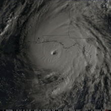
Michael reached its peak intensity as a Category 5 hurricane with maximum sustained winds of 160 mph (260 km/h) and a minimum central pressure of 919 mbar (27.14 inHg) around 17:30 UTC on October 10, as it made landfall near Tyndall Air Force Base in Florida.
Additionally, doppler weather radar from Eglin Air Force Base estimated peak winds of 178 mph (286 km/h) at 17:22 UTC, around the same location as the aircraft.
Around that time, another low-level center with a lower pressure had formed farther north, near Chesapeake Bay, as baroclinic processes began to restrengthen the former hurricane.
In the province of Artemisa, particularly in the areas of Playa de Majana and the towns of Cajio and Guanimar, which are prone to coastal flooding, evacuations were carried out, but the number of evacuees were unknown.
[35][36] Mandatory evacuation orders were issued for parts of several Florida counties, including communities such as Panama City Beach and covering over 180,000 residents.
Heavy rains from Hurricane Michael forced hundreds of people from their homes in Honduras over the weekend as the intensifying storm continued its push towards the Gulf Coast.
[3] Images circulated over social media depicting families wading through thigh-high water, rivers rushing onto streets and roads to communities cut off by mudslides.
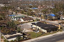
[61]: 3 Mobile homes in the regions affected by Michael were older and smaller than in other parts of the state and experienced significant to catastrophic impacts in the hardest-hit areas.
Its maximum sustained winds were estimated to be 160 mph (260 km/h) upon moving ashore, making it the most intense hurricane landfall on record for the Florida Panhandle.
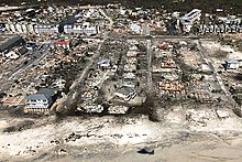
[1]: 7 The combination of Michael's storm surge and the astronomical tide submerged normally dry areas under 9–14 ft (2.7–4.3 m) of water along the coast between Tyndall Air Force Base and Port St. Joe, Florida.
[60][74] Along the immediate coast, the combination of surge and extreme winds whittled buildings down to piles of debris and left their concrete slab foundations exposed.
[83] Vehicles were tossed through parking lots and destroyed, and an McDonnell Douglas F-15 Eagle and General Dynamics F-16 Fighting Falcon used for display were flipped and damaged.
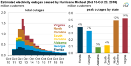
[98] Downed studio transmitter link towers and power outages resulted in the loss of nearly all television and radio stations in the Panama City region.
[1]: 10 In addition to the Mexico Beach area, coastal communities in Franklin and Gulf counties—collectively known as the "Forgotten Coast" due to a lack of infrastructure development in recent decades—were among those hardest-hit by Michael.
[72]: 15 A Florida Department of Environmental Protection survey identified 2,725 structures that sustained major flood damage in Bay, Gulf, Franklin, and Wakulla counties.
Florida State Hospital in Chattahoochee—Florida's oldest largest psychiatric hospital—was cut off from the outside world due to power disruptions, forcing aid to be dropped by helicopter.
[60] Sustained winds in coastal Okaloosa County, located west of Michael's landfall, met low-end tropical storm thresholds, punctuated by higher 60 mph (97 km/h) gusts.
Gusts in the tropical storm range extended west to Pensacola and farther inland along the westernmost stretches of the Florida Panhandle, downing trees and power lines.
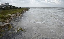
[120] Storm surge inundation of 2–2.5 ft (0.61–0.76 m) in the Pensacola area occurred ahead of the hurricane due to strong easterly winds, producing minor flooding.
[65]: 50 Minor saltwater flooding occurred along the Atlantic and Gulf coasts of South Florida due to high tides enhanced by storm surge.
Michael's outer rainbands spawned at least four waterspouts; one briefly moved ashore Sarasota County 3 mi (4.8 km) northwest of Siesta Key and was classified as an EF0 tornado.
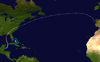
Tropical storm (39–73 mph, 63–118 km/h)
Category 1 (74–95 mph, 119–153 km/h)
Category 2 (96–110 mph, 154–177 km/h)
Category 3 (111–129 mph, 178–208 km/h)
Category 4 (130–156 mph, 209–251 km/h)
Category 5 (≥157 mph, ≥252 km/h)
Unknown