Interstate 70
[3] The construction of I-70 in Colorado and Utah is considered an engineering marvel, as the route passes through the Eisenhower Tunnel, Glenwood Canyon, and the San Rafael Swell.
Heading east, I-70 crosses between the Tushar and Pahvant ranges via Clear Creek Canyon and descends into the Sevier Valley, where I-70 serves Richfield, one of two towns of more than a few hundred people along I-70's path in Utah.
If the swell is granted this status, it arguably would be the first time a national park owes its existence to an Interstate Highway.
From Green River to the Colorado state line, I-70 follows the southern edge of the Book Cliffs.
Entering from Utah, I-70 descends into the Grand Valley, where it meets the Colorado River, which provides its path up the western slope of the Rocky Mountains.
This stretch was completed in 1992 and was an engineering marvel due to the extremely difficult terrain and narrow space in the canyon, which requires corners that are sharper than normal Interstate standards.
Because of the rugged and narrow terrain of the Rocky Mountains, I-70 is one of few roads connecting Colorado's ski resorts with Denver.
This can fool truckers and other unsuspecting drivers because one must still traverse 10 miles (16 km) of steep grade road before reaching the city.
East of Denver, I-70 makes a broad turn to the south-southeast for 30 miles (48 km), before reaching Limon and resuming its eastward journey toward Kansas.
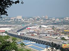
Just past the Bonner Springs Toll Plaza, I-70 crosses I-435 for the first time, which allows travelers to bypass the downtown traffic via I-435, which encircles the Kansas City metropolitan area.
Further down the highway in Kansas City, approximately three miles (4.8 km) before the 18th Street Expressway, I-70 is intersected again by another auxiliary route.
Here, I-670 (also designated "Alternate 70" on some signs) diverges, providing a more direct route that rejoins I-70 proper a few miles east in Missouri.
In the southern part of this loop, I-670 cuts directly through the downtown while I-70 bypasses the taller buildings a few blocks north near the Missouri River.
This section of the Interstate is marked as the "George Brett Super Highway", named after the Kansas City Royals third-base player who played the entirety of his career (1973–1993) at Kauffman Stadium.
Various proposals have been made to widen it (at an estimated cost of $3.5 billion) including turning it into a toll road.
The 1985 World Series between the Kansas City Royals and St. Louis Cardinals was nicknamed the "I-70 Series" because St. Louis and Kansas City are the two endpoints of I-70 in Missouri, and the highway passes within sight of both the Royals' Kauffman Stadium and, at the time, the Cardinals' Busch Stadium.
I-70 enters Indiana just to the west of Terre Haute and then crosses the Wabash River before skirting the city's south side.
After passing through miles of gently rolling terrain in rural west-central Indiana, the freeway approaches the major Indianapolis metropolitan area.
After passing just to the south of the world headquarters for Eli Lilly and Company, I-70 and I-65 have a brief concurrency through the eastern side of Downtown Indianapolis.
I-74 meets I-70 at the western interchange with I-465, eastern access to I-74 can take place via its concurrency around the southern portion of the I-465 loop.
Immediately to the east of this border, travelers notice a unique teal-blue arch that spans the width of the freeway, with a "Welcome to Ohio" greeting sign above the eastbound lanes.
Columbus is bounded by I-270 and is roughly centered on the intersection of I-70 and I-71, which share the same asphalt through a notoriously congested 1.5-mile (2.4 km) stretch locally known as the "South Innerbelt" or, more commonly, "The Split".
On the north side of the highway, a former strip mine was developed into a retail area called The Highlands.
It is characterized by sharp curves, limited sight distance, narrow shoulders, and lack of merge lanes at interchanges.
Uniquely, I-70 indirectly serves a branch of the Washington Metro at Shady Grove station via I-370, which only connects to I-270.
Utah and Colorado, however, pressured the federal government to extend the planned freeway farther west, arguing a direct link between Denver and Salt Lake City was vital for an effective highway system.
Many motorists include I-70 as part of their cross-country drives between New York City and Los Angeles (which are accessible to I-70 via other Interstates).
The former freeway from I-695 to MD 122 is being converted into a two-lane parkway to be renamed Cooks Boulevard,[14] maintained by the Maryland State Highway Administration.
No suspect has ever been apprehended despite the widespread publicity the murders generated, including their being featured several times on the television show America's Most Wanted and Unsolved Mysteries.
[citation needed] John Allen Muhammad and Lee Boyd Malvo, the duo responsible for the DC sniper attacks, were apprehended at a rest stop on I-70 near Myersville, Maryland, in 2002.