Iceberg A-38
A-38A and A-38B increased speed in open sea and grounded in shallower waters to the east of South Georgia Island in December 2003.
The remainder of A-38B remained grounded, interfering with the foraging routes of seals and penguins in South Georgia, resulting in the deaths of their young.
The calving was witnessed over a period of decades as inlets in the shelf, which filled with sea ice, snow and small icebergs, gradually grew in size.
It was first recognised on 13 October 1998 by United States National Ice Center scientist Mary Keller from imagery provided via the Defense Meteorological Satellite Program, though Glenn Grant and Jeff Otten of the United States Antarctic Program's Palmer Station claimed to have spotted the iceberg the same day.
The speed of the icebergs varied according to the quantity and thickness of surrounding sea ice, moving much slower in winter than in summer.
[6] A-38B remained grounded 100 kilometres (62 mi) off South Georgia and on 12 April 2004 was measured at 25 nautical miles (46 km) in length.
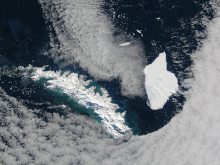
[2] A-38 offered researchers an opportunity to observe the breaking up and decay of an iceberg, though satellite imagery was affected by heavy cloud cover in the region around South Georgia.
As the iceberg was grounded (and therefore stationary) high-resolution imagery from the Advanced Spaceborne Thermal Emission and Reflection Radiometer satellite could be ordered to investigate it.