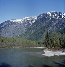
Incomappleux River
The area has been studied since 2000 by Valhalla Wilderness Society as a part of their Inland Temperate Rainforest campaign, and the upper Incomappleux was included in the Selkirk Mountain Caribou Park proposal after groundbreaking biodiversity research by biologists Toby Spribille and Curtis Björk, sponsored by Valhalla Wilderness Society, found over 300 species of lichens in the Incomappleux, most of them in the ancient forest.
The Incomappleux Valley was declared a conservancy in 2023 but the remainder of the Selkirk Mountain Caribou Park proposal, containing critical old growth inland rainforest corridors still remains unprotected.
The name "Incomappleux" is derived from the Sinixt word nk'mapeleqs, meaning "point at end (of lake)".
[3] After the mid-1880s, visitors could enter the valley from the Canadian Pacific Railway (CP) main line, moving southward through the Glacier National Park area into the valley and following the river to its mouth, but this involved a long climb up and over a high mountain and a long trek down to the river.
[6] Access was from the south end through a deep, narrow, steep-sided gorge where the miners built a roadway about 0.5 km long out of timbers perched on the side of the cliff and anchored into rock crevices.
Although most claims were accessed from the south, the Dunvegan group, at the headwaters of the river,[8] was reached by a 16-kilometre (10 mi) trail from the CP station at Albert Canyon.
[11] Around 61 metres (200 ft) high,[8] the narrow canyon, which is about 5 kilometres (3 mi) from the mouth, funnels the glacial waters.
[5] In 2003, two experienced alpinists (Michel Bastien and Yves Laforest), a videographer (Aurélie Chabaud) and a multimedia student (Martin Champagneur) set out to climb Mount Hope for a childhood cancer charity then descend the Incomappleux River by kayak to Upper Arrow Lake at Beaton, British Columbia.
[20][21] After the one at the mouth connecting to Lardeau City was washed out, a temporary 5-by-12-metre (18 by 40 ft) cable ferry commenced in June 1893.
[26] The lower bridge provided a connection in 1898,[27] when the wagon road up the west side of the river was completed as far as the Camborne ferry.
[29][30] In 1904, the wagon road was extended up the west side of the river from Camborne, and a bridge replaced the ferry at Boyd Creek.
[35] Conservancies are a class of protected areas in the province that allow some low-impact commercial and industrial uses, but prohibit activities such as large scale logging and road construction.