Independence Pass (Colorado)
A scenic overlook near the pass allows visitors to take in the alpine tundra environment above treeline, and offers excellent views to the east of Mount Elbert, Colorado's highest peak and the second-highest mountain in the contiguous United States.
As part of the Continental Divide, it was the limit of European settlement in the region at the time, with the land to the west reserved for the Ute people.
At the pass, the main ridge of the Sawatch Range, and thus the Continental Divide, turns from running generally south to more southwesterly.
The pass is split evenly between Pitkin and Lake counties, as well as White River and San Isabel national forests.
The former approach uses the narrow valley of the Roaring Fork River, a tributary of the Colorado, which rises from Independence Lake west of the pass.
Open grassy expanses are occasionally broken by low shrubbery and bare patches of rock, particularly on the steep slope to the north.
One of the earliest sightings by a European-American was in 1806, when Zebulon Pike, mapping the southern boundary of the Louisiana Purchase, spotted the gap in what would later be named the Sawatch Range from the upper Arkansas River valley.
[14] Governor Frederick Walker Pitkin had ordered all settlers to stay to the east of the Divide, as the state and federal governments had not made peace with the Utes.
[14] In two years they produced gold worth $190,000 ($6 million in modern dollars[15]), funding the construction of a stamping mill and sawmill.
The federal Works Progress Administration (WPA) oversaw the construction of the Twin Lakes Tunnel, which diverted water from Grizzly Reservoir, on Lincoln Creek, a southern tributary of the Roaring Fork, to Twin Lakes, where it was used for irrigation purposes by beet and watermelon farmers in the Rocky Ford and Ordway areas.
A travel guidebook for automobile touring produced by the Federal Writers' Project gave as one route the trip along Highway 82 from Twin Lakes.
Thinning pines, gnarled and stubby from their fight for existence, give way to bare boulders, hardy grasses and the alpine vegetation of a world above the clouds.
An arctic meadowland overshadowed only by the topmost notches of the Sawatch Range, it rises far above the peaks that towered high when viewed from the Lake Creek valley.
[20]After World War II, Aspen began to grow and prosper again due to the establishment of a popular ski resort, an annual music festival, and a relaxed lifestyle which attracted many celebrities and corporate executives to the city.
Visitors to Aspen generally had to take Highway 82 up from Glenwood Springs or fly in, as few wanted to drive over the unpaved pass road.
Animals in the alpine zone include ptarmigans, small burrowing species like pika, marmots, and pocket gopher, and mountain goats.
Between the pass and Difficult Campground, 3 miles (4.8 km) east of Aspen, there are many popular rock climbing areas, some with grades up to 5.12 under the Yosemite Decimal System.
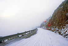
CDOT tries to reopen just before Memorial Day weekend in late May, the traditional beginning of summer in the United States, when enough of the accumulated snowpack has melted to make it possible to clear and repair the road.
When the road is closed, Aspen is isolated from the east and Highway 82 up the valley from Glenwood Springs becomes the only vehicular access to the city during its busy ski season.
They are generally either unaware of the restriction and following routes plotted by their GPS devices, or aware of it and willing to risk the fine for the sake of the time and distance saved.
CDOT put up larger signs advising drivers of the ban and worked with GPS device manufacturers so their software notes the restriction.
[35] CDOT advises anyone coming to the pass for outdoor recreation to take precautions against the effects of the high altitude and the changeable weather.
In the 1930s, as a relief project during the Great Depression, a crew from the Civilian Conservation Corps replanted the slopes around Independence, by then abandoned for two decades.
Other than paving the road, CDOT was unable to undertake any significant improvements to the highway corridor due to its projects elsewhere in the state and the requirement to coordinate efforts with the Forest Service, which owns most of the damaged land.
[37] Beginning in 1976, Bob Lewis, an environmental activist in Aspen, organized revegetation efforts on some sections of the pass near the road that were having serious erosion problems.
Its first project, coordinated with the Forest Service, CDOT and Pitkin County, was the reconstruction of a curve near the popular Weller Lake trailhead.
[38] The success of the Weller Curve project cleared the way for work on the Top Cut, the 1.5-mile (2.4 km) stretch just below the summit on the western side, which includes the most seriously eroded slopes anywhere in the pass corridor.
[39] In 2009 the foundation began removing metal and rebar snow fences embedded in the soil just below the pass summit during the 1960s as part of an abortive project to increase meltwater capture by the Twin Lakes Tunnel.
According to the IPF, they were an aesthetic blight as well as an environmental problem, and had to be removed using a team of mules and helicopters due to the wilderness area restrictions.
Along with the Aspen Center for Environmental Studies, the foundation also cosponsors a "My Independence" all-day walking tour of the pass for adults that covers ecological topics in depth.