Interstate 70 in Colorado
The United States Department of Transportation (USDOT) lists the construction of I-70 among the engineering marvels undertaken in the Interstate Highway System and cites four major accomplishments: the section through the Dakota Hogback, Eisenhower Tunnel, Vail Pass, and Glenwood Canyon.
The plateau ends just past the state line and the highway descends into the Grand Valley, formed by the Colorado River and its tributaries.
[2] I-70 exits the valley through De Beque Canyon, a path carved by the Colorado River that separates the Book Cliffs from Battlement Mesa.
[4] After the canyon winds past the Book Cliffs, the highway follows the Colorado River through a valley containing the communities of Parachute and Rifle.
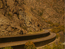
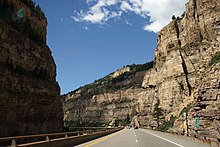
Both the federal and state departments of transportation have praised the engineering achievement required to build the freeway through the narrow gorge while preserving the natural beauty of the canyon.
[2] To minimize the hazards along this portion, a command center staffed with emergency response vehicles and tow trucks on standby monitors cameras along the tunnels and viaducts in the canyon.
[8] The highway departs the Colorado River near Dotsero, the name given to the railroad separation for the two primary mountain crossings, the original via Tennessee Pass/Royal Gorge and the newer and shorter Moffat Tunnel route.
Several parts of the approach to the pass feature large fences that prevent wildlife from crossing the freeway and direct the animals to one of several underpasses.
[1][11] The highway descends to Dillon Reservoir, near the town of Frisco, and begins one final ascent to the Eisenhower Tunnel, where the freeway crosses the Continental Divide.
[2] The freeway follows Clear Creek down the eastern side of the Rockies, passing through the Veterans Memorial Tunnels[13] near Idaho Springs.
[2] This portion features grade-warning signs with unusual messages, such as "Trucks: Don't be fooled", "Truckers, you are not down yet", and "Are your brakes adjusted and cool?".
[18] While State Highway 470 (SH 470) and E-470 are not officially branches of I-70, they are remnants of plans for an I-470 outer beltway around Denver that were canceled when the allocated funds were spent elsewhere.
The highway crossed the mountains along a trail blazed by a railroad surveyor and captain in the American Civil War, cresting at Berthoud Pass.
[24] Around the time the U.S. Highway system was formed, the portion of the Midland Trail through Glenwood Canyon, known as the Taylor State Road, was destroyed by a flood.
[25] To keep these routes over the Rockies competitive with alternatives in other states, the Colorado Department of Highways relied on ingenuity to keep the roads safe.
[11]Colorado held several meetings to convince reluctant Utah officials they would benefit from a freeway link between Denver and Salt Lake City.
Military planners approved the extension but moved the western terminus south to Cove Fort, using I-70 as part of a link between Denver with Los Angeles instead of Salt Lake City.
Utah officials objected to the modification, complaining they were being asked to build a long and expensive freeway that would serve no populated areas of the state.
The amount of traffic through the tunnel exceeded predictions, and efforts soon began to expedite construction on the second tube (the Johnson bore), which was finished on December 21, 1979.
Bonnema entered the tunnel for the first time on November 9, 1972, prompting 66 workers to temporarily walk off the job; most returned the next day.
[22] This alternative sparked a nationwide controversy as it would require an easement across federally protected lands, through what is now called the Eagles Nest Wilderness.
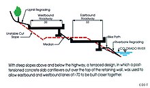
The engineers added infrastructure to accommodate wildlife and had significant portions of the viaducts constructed offsite and lifted in place to minimize the environmental footprint.
[22] With the Eisenhower Tunnel finished, the last remaining obstacle for I-70 to be an interstate commercial artery was the two lane, non-freeway portion in Glenwood Canyon.
"[31] A portion of the project included shoring up the banks of the Colorado River to repair damage and remove flow restrictions created in the initial construction of US 6 in the 1930s.
The $1.2 billion project, financed through a public–private partnership with Kiewit and Meridiam, added new express toll lanes; the below-grade freeway was covered with a four-acre (1.6 ha) park between Clayton and Columbine streets.
The situation was made worse as no one answered at the phone number provided with the cargo, and an unknown liquid was leaking from one of the torpedoes.
[49] In 2014, mile-marker 420 was altered by CDOT to read "Mile 419.99" following repeat thefts of the original sign due to the significance of the number 420 in cannabis culture.
A semi-trailer truck descending the grades as the freeway entered the greater Denver area, driven by Rogel Aguilera Mederos, attempted to downshift, but he was unable re-engage the transmission.
[51] This resulted in the vehicle rapidly increasing in speed, with witnesses seeing the truck out of control near the Genesee exit, nine miles (14 km) from where the accident would occur.
The company had previously been fined and cited for numerous brake-related violations as well as employing inexperienced truck drivers who were not fluent in English.


![A highway near the top of a ridge. On either side of the highway are big yellow signs reading, "Trucks, Don't be Fooled—4 more miles [6.4 km] of steep grades and sharp curves".](http://upload.wikimedia.org/wikipedia/commons/thumb/a/a6/TrucksDontBeFooled.JPG/220px-TrucksDontBeFooled.JPG)