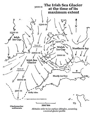
British-Irish Ice Sheet
Once through this constriction, in the Anglian Glaciation, the ice spread out into a great lobe, in the area now occupied by the Celtic Sea and the approaches to the Bristol Channel.
It is not known how far inland this ice extended, but there are scattered glacial deposits in the Bridgwater - Glastonbury district—these may mark the easternmost extent of the glacier.
The ice of the Irish Sea Glacier certainly pressed against the northern coasts of the islands, and accumulating evidence seems to show that this occurred some time after 24,000 years ago.
One current theory is that the glacier moved to its outermost position by a "lobate surge partially propagated by high porewater pressures within deformable marine substrate",[5] leaving parts of South Wales, the Bristol Channel and the coasts of SW England free of glacier ice.
Work in analogous situations in Marie Byrd Land, Antarctica,[7] suggests that the ice surface altitude over the mountains might have been around 800m lower than predicted.