Jia Dan
[3] During Emperor Xuanzong's Tianbao era (742–756), Jia Dan passed the imperial examinations and was made the sheriff of Linqing County (臨清, in modern Liaocheng, Shandong).
After he submitted suggestions on the matters of the times to Emperor Xuanzong, he was moved to be the sheriff of Zhengping County (正平, in modern Yuncheng, Shanxi) — closer to the capital Chang'an, and therefore considered a promotion despite it being the same level of office.
[2][5][6] As the minister of vassal affairs, he would have met with foreign envoys in order to acquire information about their native countries.
[10] In 793, Jia was recalled to Chang'an to serve as You Pushe (右僕射), one of the heads of the executive bureau of government (尚書省, Shangshu Sheng).
Emperor Dezong agreed and directly made the official Li Yuansu (李元素) the military governor of Yicheng.
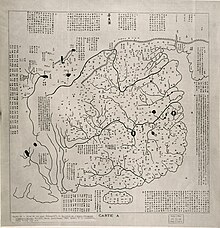
[12] In 801, Jia completed a 40-volume work that included a large map of the Chinese and the non-Chinese populations, and descriptions of the various circuits of Tang as well as foreign nations (see further below).
Emperor Dezong awarded him with a number of silk and silver items, as well as a horse, and created him the Duke of Wei.
[2] Jia Dan was an important contributor to the study of geography in China, of note are his writings on foreign countries.
[13][14] The map depicted China and other countries including its former colonies in Central Asia that were lost to the Uyghurs and Tibetans.
[1] This was confirmed by the contemporary Arab merchant Shulama, who noted that the draft in Chinese junk ships were too deep to enter the Euphrates, forcing them to land passengers and cargo ashore on smaller boats.
[19] A small branch of this extensive second trade route led all the way to Dar es Salaam in Tanzania, East Africa.