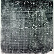
Huayi tu
It is the earliest surviving map that displays maritime connections between China and other foreign states.
It covers an area bounded in the north by the Great Wall of China, northeast by the present-day Heilongjiang province, extending south to the island of Hainan.
[1][5] At the edges of the map are a few other states such as Korea (Goryeo) on the northeast and India (Tianzhu) on the southwest.
[7] The later Huayi Tu map covers China during the Jin and Southern Song dynasty.
The texts arranged around the edges of the map provides information from historical and other sources briefly explaining markers such as the Great Wall, the size of the empire, brief descriptions of Korea, Japan and other foreign states as well as lists of the states to the south and west of China.