Joel Gascoyne
1704) was an English nautical chartmaker, land cartographer and surveyor who set new standards of accuracy and pioneered large scale county maps.
After achieving repute in the Thames school of chartmakers, he switched careers and became one of the leading surveyors of his day and a maker of land maps.
He is best known for his maps of the colonial Province of Carolina, of the county of Cornwall, and the early 18th-century Parish of Stepney, precursor of today's East End of London.
Born into a seafaring family prominent in the port of Hull, Yorkshire, Joel Gascoyne was baptised at Holy Trinity Church on 31 October 1650.
At 18 Gascoyne was apprenticed for seven years to John Thornton, citizen and draper of London, a leading member of the Thames chartmakers.
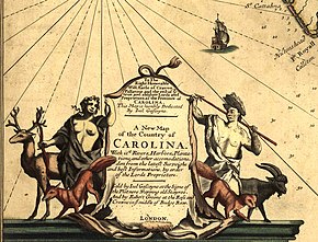
Gascoyne acquired such fame that his counsel was twice sought by administrator of the Navy Samuel Pepys and his services were commissioned by the proprietors of the colony of Carolina.
[4] In 1678 Gascoyne drew on vellum for Captain John Smith a coloured portolan chart[5] pasted on four hinged oak boards; the western half survives at the National Maritime Museum Greenwich.
[9] On 11 December, King James II fled London when popular support for his government collapsed, ushering in the Glorious Revolution.
[12] For the next six years he was away in Cornwall (see below), but on his return he was commissioned to survey several estates, including Enfield Chase and the manor of Great Hasely.
Estate surveyors were disliked by farmers and tenants, who might refuse them access, wrote Eva Taylor: This was partly because they feared that their holdings would prove larger than the old written records indicated, with a consequent raising of the rent, or more generally that 'concealed lands' would be revealed...
[21] It gave Gascoyne the collateral opportunity to survey all over the county, hence to make his great one-inch map on his own account.
[20] On March 27, 1699, Gascoyne issued a broadsheet addressed to the nobility and gentry of the county of Cornwall inviting them to subscribe to his map, which was nearly finished.
[23] Into this space he mapped a mass of detail: I have laid down as many of the Villages and Cottages, with other Remarkable Places, as so Narrow a Compass will admit, without making it burthensom to the Eye.
[5] When tested with a modern Ordnance Survey map, the accuracy of Gascoyne's interpoint distances is so consistently good[26] as to be surprising.
Incidentally, the Ordnance Survey did not manage to put parish boundaries on their one-inch maps until the middle of the nineteenth century.
By this time only three copies of the original map could be found, two of them in museums but in unsuitable condition, the third privately owned by a Cornish architect, who loaned it to the publishers.
[20] For a long time the Stowe Atlas was unknown to historians, but it reappeared in the 20th century and is now in Kresen Kernow the Cornish public archives.
Not only were the place-names too Anglicised for a Cornishman, the elaborate compass roses[43] and colourful cartouches[44] were typical of Joel Gascoyne's work, as was the maritime[45] flavour.
Writing of the Lanhydrock Atlas, Fiona Reynolds said:In the three hundred years since Joel Gascoyne's death, surveying and mapping have developed beyond comprehension.
Yet, today, in this age of computer and satellite technologies, we still marvel at his achievement, wondering at the sheer quality and aesthetic beauty of the maps...[48] while Oliver Padel said:The plans are astonishingly accurate, and the field boundaries nearly always correspond very closely to those shown on the large-scale maps of the late nineteenth and earlier twentieth century, even in very minor details.
The medieval parish of St Dunstan's, Stepney was an area of 7 square miles lying between the wall of the City of London and the River Lea to the east, where Essex began.
The local government, known as the Vestry,[54] was responsible for a host of functions — the relief of poverty, highways, law and order, vagrants, the oversight of charities — and the collection of taxes to pay for these things.
[55] John Strype writing thirteen years later described Stepney as "rather a Province than a Parish",especially if we add, that it contains in it both City and Country: For towards the South Parts, where it lies along the River Thames for a great way, by Limehouse Poplar, and Radcliff, to Wappin, it is furnished with every thing that may intitle it to the Honour (if not of a City, yet) of a great Town; Populousness, Traffick, Commerce, Havens, Shipping, Manufacture, Plenty and Wealth, the Crown of all... On the other Side, Northward, this Parish hath the face of a Country, affording every thing to render it pleasant, Fields, Pasture-Grounds for Cattle, and formerly Woods and Marshes.
[56]While the parish of Stepney was much smaller (and flatter) than Cornwall, the map was to be on a bigger scale (1:5,550, or about 11 inches to the mile), and had to depict fine urban detail, because its fiscal purpose was to show tax-liable properties, such as fields, terraces and stand-alone houses, and even courts and alleys.
Professor Ravenhill, who wrote an introduction to a modern edition of Gascoyne's map, referred to the danger of surveying in "the often squalid and congested purlieus of late seventeenth-century London where the welcome accorded to seemingly inquisitive surveyors could have been anything but warm and co-operative.
High-status individuals had country estates in early Stepney and a number are buried im its churchyard, as are many sea captains.
Nearly opposite to that, also marked "2", is "the Mercers Almes Houses" The numerous bowling greens reflect the leisure character of the area.
[71] The charitable use of the area is further shown by the field for the support of "Poor of Criplegate";and, to its left, numeral "9", denoting "Jews' Burial Place".
Running due east from the Tower of London was the Ratcliff Highway, a coastal route originating in Roman times.
[87] When Gascoyne negotiated with the Vestry of St Dunstan Stepney in 1702, he could see a prominent inscribed stone in the church, the image of which is reproduced here.