Karakalpakstan
[citation needed] However, the evaporation of the Aral Sea has made Karakalpakstan one of Uzbekistan's poorest regions.
Crop failures have deprived about 48,000 people of their main source of income and shortages of potable water have created a surge of infectious diseases.
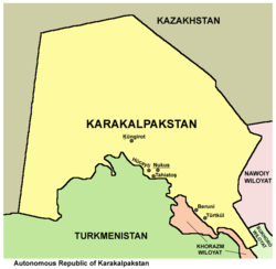
[9][needs update] Karakalpakstan is now mostly desert and is located in western Uzbekistan near the Aral Sea, in the lowest part of the Amu Darya basin.
According to the constitution, relations between Karakalpakstan and Uzbekistan are "regulated by treaties and agreements" and any disputes are "settled by way of reconciliation".
"[14][15] In July 2022, large protests broke out in the region over a proposed constitutional change which would strip Karakalpakstan of its autonomy.
Other than the capital Nukus, major cities include Xojeli, Taqiyatas, Shimbay, Qońirat (Kungrad) and Moynaq.
Dynamics of the number and ethnic composition of the population of Karakalpakstan according to the All-Union censuses of 1926–1989: The economy of the region used to be heavily dependent on fisheries in the Aral Sea.
It is now supported by cotton, rice, and fruits, such as plums, pears, grapes, and apricots, in addition to all kinds of melons.
Hydroelectric power comes from a large Soviet-built station on the Amu Darya, which was once heavily populated and supported extensive irrigation based agriculture for thousands of years.
[23] The autonomous republic of Karakalpakstan consists of 16 districts (listed below) and one district-level city: Nukus (number 1 on map).
[25] There are 12 cities (Nókis, Mańģit, Beruniy, Xaliqabat, Qońirat, Moynaq, Taqiyatas, Tórtkúl, Xojeli, Shimbay, Shomanay, Bostan) and 26 urban-type settlements in Karakalpakstan.
[citation needed] Qaraqalpaqstan tеlеvideniesi is an Uzbek television channel that broadcasts to the autonomous republic of Karakalpakstan.