Karoo
The Karoo is partly defined by its topography, geology and climate, and above all, its low rainfall, arid air, cloudless skies, and extremes of heat and cold.
The Great Karoo straddles the 30° S parallel on the west of the continent, in a similar position to other semidesert areas on earth, north and south of the equator.
Turning north from the N1 between Touws River and Beaufort West, at Matjiesfontein, the road ascends the Great Escarpment through the Verlatenkloof Pass to reach Sutherland, at 1456 m above sea level, which is reputedly the coldest town in South Africa with average minimum temperatures of −6.1 °C during winter.
This is not only because of the clear skies, absence of artificial lights, and high altitude, but also because it is tectonically completely inactive (meaning that there are no fault lines or volcanoes nearby,[13] and no earth tremors or earthquakes occur, even at great distances).
The main towns of the region are situated along this northern strip of the Klein Karoo: Montagu, Barrydale, Ladismith, Calitzdorp, Oudtshoorn, and De Rust, as well as such well-known mission stations such as Zoar, Amalienstein, and Dysselsdorp.
The Klein Karoo can only be accessed by road through the narrow defiles cut through the surrounding Cape Fold Mountains by ancient, but still flowing, rivers.
The only exit from the Klein Karoo that does not involve crossing a mountain range is through the 150 km-long, narrow Langkloof valley between Uniondale and Humansdorp, near Plettenberg Bay.
[13] It covers two-thirds of South Africa and extends in places to 8000 m below the land surface, constituting an immense volume of rocks which was formed, geologically speaking, in a short period of time.
[5][13][14] The Karoo Supergroup was formed in a vast inland basin starting 320 million years ago, at a time when that part of Gondwana which would eventually become Africa, lay over the South Pole.
[11][22] Icebergs that had calved off the glaciers and ice sheets to the north deposited a 1 km-thick layer of mud containing dropstones of varying origins and sizes into this basin.
[24][25][26] Finally, about 180 million years ago, volcanic activity took place on a titanic scale, which brought an end to a flourishing reptile evolution.
Since this massive extrusion of lava, Southern Africa has undergone a prolonged period of erosion, exposing the older, softer rocks, except where they were protected by a cap of dolerite.
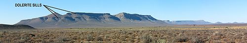
The genera present include: The lava outpourings that ended the Karoo deposition of rocks, not only covered the African surface, and other parts of Gondwana with a 1.6 km thick layer basaltic lava,[14] but it also forced its way, under high pressure, between the horizontal layers of sedimentary rocks belonging to the Ecca and Beaufort groups, to solidify into dolerite sills.
These "Enon Conglomerates", as they are known, were deposited by high energy, fast flowing rivers,[14] and are found between Calitzdorp and Oudtshoorn, where they form the strikingly red "Redstone Hills".
[1][4][5][11][15][29] The succulent Karoo biome is dominated by dwarf, leafy-succulent shrubs, and annuals, predominantly Asteraceae, popularly known as Namaqualand daisies, which put on spectacular flower displays covering vast stretches of the landscape in the southern spring-time (August–September) after good rains in the winter.
It is defined primarily by the dominance of dwarf (less than 1 m high) shrubs with a co-dominance of grasses especially towards the north-east and east where it grades into the grassland biome of the highveld and the Eastern Midlands.
It also promotes the replacement of the grasses by shrubs, especially the less edible varieties such as the threethorn (Rhigozum trichotomum), bitterbos (Chrysocoma ciliata), and sweet thorn (Acacia karroo).
Not only people followed these herds for the easy meat they provided, but also lions, leopards, cheetahs, African wild dogs, hyenas, and jackals preyed on them.
[7] The riverine rabbit, a critically endangered animal, lives exclusively in seasonal river basins and a very particular set of scrubland in the central semiarid region in the Karoo.
The ostrich is found throughout Africa, but the most handsome specimens came from the Klein Karoo, where the dry weather, but plentiful water in the streams formed an ideal habitat for these large, flightless birds.
[5][15] In the 1860s, a farmer in the Graaff-Reinet district was apparently the first person to demonstrate that the ostrich could successfully be domesticated, bred in captivity, and the eggs hatched in incubators, while still producing the magnificent feathers.
[5][15] The first European settlers landed in the Cape of Good Hope in 1652, and between 1659 and 1664, made several unsuccessful attempts to penetrate the Great Karoo from the south-west.
[7][15] These were the trekboers of the mid-1700s, who led a nomadic existence, enduring great hardships in the relentless aridity, the intense heat (such that even their dogs could not walk on the scorching ground and had to be lifted into the overcrowded wagons), and the bitter cold in winter, especially at night.
[7] The Ntu-speaking agriculturalists to the east of the Great Karoo did not occupy this arid region due to the scarce rainfall which prevented the farming of cattle.
From there, it reached the top of the African Plateau near Three Sisters along a valley with such a low gradient that passengers were (and still are) hardly aware that they were ascending the Great Escarpment.
During the Second Anglo-Boer War of 1899–1902, three Republican commando units, reinforced by the sympathizers ("rebels") from the Cape Colony, conducted widespread operations throughout the Karoo.
Fought both conventionally and as a guerrilla struggle over the Karoo's vast expanses, it was a bloody war of attrition wherein both sides used newly developed technologies to their advantage.
A prime example still "guards" a bridge over the Buffels River, 12 km (7.5 mi) to the east of the town of Laingsburg, in the Lower Karoo, between Matjiesfontein and Beaufort West.
Recently, nature reserves and game farms have been established in many parts of the Great Karoo, turning what was once regarded as a forbiddingly desolate and unattractive geographical barrier into a tourist destination.
[46] Rudyard Kipling, in his 1901 poem "Bridge-Guard in the Karroo", evoked the loneliness experienced by blockhouse soldiers at Ketting station on the Dwyka River while guarding the Karoo railway track, a lifeline during the South African War.