Karst
In regions where the dissolved bedrock is covered (perhaps by debris) or confined by one or more superimposed non-soluble rock strata, distinctive karst features may occur only at subsurface levels and can be totally missing above ground.
[5] The English word karst was borrowed from German Karst in the late 19th century,[6] which entered German usage much earlier,[7] to describe a number of geological, geomorphological, and hydrological features found within the range of the Dinaric Alps, stretching from the northeastern corner of Italy above the city of Trieste, across the Balkan peninsula along the coast of the eastern Adriatic to Kosovo and North Macedonia, where the massif of the Šar Mountains begins.
Primarily discussing the karst regions of the Balkans, Cvijić's 1893 publication Das Karstphänomen describes landforms such as karren, dolines and poljes.
Karst is also most strongly developed where the water table is relatively low, such as in uplands with entrenched valleys, and where rainfall is moderate to heavy.
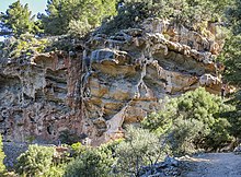
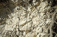
On exposed surfaces, small features may include solution flutes (or rillenkarren), runnels, limestone pavement (clints and grikes), kamenitzas collectively called karren or lapiez.
Rivers which emerge from springs may produce tufa terraces, consisting of layers of calcite deposited over extended periods of time.
In caves, a variety of features collectively called speleothems are formed by deposition of calcium carbonate and other dissolved minerals.
In the United Kingdom for example extensive doline fields have developed at Cefn yr Ystrad, Mynydd Llangatwg and Mynydd Llangynidr in South Wales across a cover of Twrch Sandstone which overlies concealed Carboniferous Limestone, the last-named locality having been declared a site of special scientific interest in respect of it.
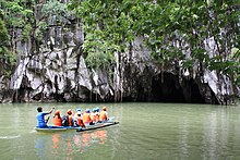
[27] Kegelkarst is a type of tropical karst terrain with numerous cone-like hills, formed by cockpits, mogotes, and poljes and without strong fluvial erosion processes.
This terrain is found in Cuba, Jamaica, Indonesia, Malaysia, the Philippines, Puerto Rico, southern China, Myanmar, Thailand, Laos and Vietnam.
Sedimentation resumed and further limestone strata were deposited on an irregular karst surface, the cycle recurring several times in connection with fluctuating sea levels over prolonged periods.
[32] Characterization of karst aquifers requires field exploration to locate sinkholes, swallets, sinking streams, and springs in addition to studying geologic maps.
[34] U.S. Geological Survey dye tracing has determined that conventional groundwater models that assume a uniform distribution of porosity are not applicable for karst aquifers.
[36] Voids in karst aquifers can be large enough to cause destructive collapse or subsidence of the ground surface that can initiate a catastrophic release of contaminants.
For example, in the Barton Springs Edwards aquifer, dye traces measured the karst groundwater flow rates from 0.5 to 7 miles per day (0.8 to 11.3 km/d).
Geologists are concerned with these negative effects of human activity on karst hydrology which, as of 2007[update], supplied about 25% of the global demand for drinkable water.
Sinkholes can develop gradually as surface openings enlarge, but progressive erosion is frequently unseen until the roof of a cavern suddenly collapses.
In the United States, sudden collapse of such a cavern-sinkhole swallowed part of the collection of the National Corvette Museum in Bowling Green, Kentucky in 2014.
Many karst-related terms derive from South Slavic languages, entering scientific vocabulary through early research in the Western Balkan Dinaric Alpine karst.
This includes biological, chemical, ecological, geomorphological, hydrogeological, hydrological, political, socio-economical, and other processes over a variety of spatial and temporal scales in karst regions, with the purpose of understanding karst aquifers and ecosystems, and the development of the surface and underground structure, so that the environment can be protected and human activities planned effectively.