Keyser, West Virginia
[7] The first local land grant was issued by Lord Fairfax to Christopher Beelor on March 20, 1752.
The place was first called Paddy Town, for Patrick McCarty, an Irish immigrant who came to then-Hampshire County, Virginia, sometime after 1740.
In 1861, the American Civil War came to New Creek Station in then-Hampshire County, Virginia, when the Union established Fort Fuller.
The railroad that had been a blessing to the town had turned into a curse, drawing repeated assaults by Confederate forces.
Because of its geography, a relatively flat plain in a valley surrounded by mountains and open to many approaches, New Creek was an easy target for Confederates.
[9] Complete disaster finally visited New Creek on November 28, 1864, when Fort Fuller was overcome; the Confederates then took over the town, destroying the earthworks and nearly all the buildings.
A smaller Confederate force was then sent to Piedmont, where they managed to burn the Baltimore and Ohio Railroad's roundhouse, a workshop, and other machinery before they were turned away by Company A Sixth West Virginia Volunteers.
In addition to the headquarters, the renamed town of Keyser received repair shops and a roundhouse, lifting employment and economic activity.
[11] Keyser played an early and prominent role in the Great Railroad Strike of 1877, attracting the attention of national news and the involvement of Federal authorities.
Infrastructure improvements attracted more industry, and Keyser's private sector began to diversify beyond its sometimes problematic dominant employer, the Baltimore & Ohio.
In 1924, Keyser experienced massive flooding of the Potomac River, which brought widespread damage to homes and businesses.
Although Keyser's fortunes were generally tied to the national economy through the centuries, the town did not experience the 1990s economic boom in the same way as other parts of the country.
Since losing much of its manufacturing base, the town found employment via health care, education, and service jobs.
The Thomas R. Carskadon House and Mineral County Courthouse are listed on the National Register of Historic Places.
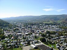
[13] It is situated in a valley on the south side of the North Branch of the Potomac River at its junction with New Creek.
On Keyser's western edge is the Allegheny Front, rising 2,631 feet above sea level at this point along its range.
Immediately across the river, in McCoole, Maryland, another portion of the New Creek Mountain ridge features a massive outcropping of Oriskany or Ridgeley sandstone known as Queens Point, a popular cliff from which to take in views of Keyser.
[14] The southern edge of Keyser is not bound by geology, as the valley here stretches farther south than the city limits.
[15] Eventually, the wind farm reached 162 turbines, making it the largest east of the Mississippi.
The south end of Keyser features a relatively newer neighborhood, on the west side of U.S. Route 220, with most of the homes built in the 1960s and 1970s, known as Airport Addition, as it was once the site of a small airfield.
At its north end, 220 crosses the Potomac via the newly reconstructed Memorial Bridge, heading toward Cumberland, Maryland.
The type locality of the Silurian/Devonian Keyser Formation, a limestone, is located in a quarry and roadcut east of the town.
The city and surrounding county are served by a local newspaper, the Mineral News and Tribune.