Kittson County, Minnesota
Evidence has been found that the Laurel, Arvilla, St. Croix, and Blackduck complexes were the area's early occupants.
Pembina, North Dakota's oldest settlement, across the Red River from Kittson County, dates from 1797, when the first trading post was established by Charles Baptiste Chaboillez of the Northwest Fur Company.
Alexander Henry the younger, who erected a fort for the North West Company in Pembina, is thought to be the first white man to test agriculture in the valley.
Joe Rolette, who started a fur post for the American Fur Company in Pembina, and Norman W. Kittson (for whom the county is named),[3] were two early entrepreneurs who opened this area by developing the Red River Ox Cart trails and broadening the use of oxcarts.
The railway extended through the western part of the county, with Donaldson, Kennedy, Hallock, Northcote, Humboldt and St. Vincent along the line.
The Soo Line railroad was completed in 1904 and the communities of Karlstad, Halma, Bronson, Lancaster, Orleans and Noyes were established.
[6] Three sites in the county are listed in the National Register of Historic Places: the St. Nicholas Orthodox Church, in Caribou Township; the burial mounds known as the "Lake Bronson Site", in Norway and Percy Townships; and the Lake Bronson State Park WPA/Rustic Style Historic Resources, which include an observation tower and several buildings.
Lake Bronson State Park also has interpretive sites for the tower, a pioneer cemetery and the WPA camp.
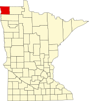
Kittson County is in Minnesota's northwest corner, on the borders of North Dakota and Canada.
The Joe River flows northwest out of the county into Canada, to discharge into the Red a few miles past the international border.
[7] The terrain slopes to the north and west, with its highest point near the southeast corner at 1,079 ft (329 m) ASL.
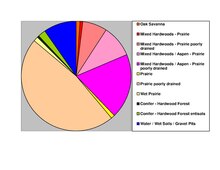
Remnants of McCauleyville Beach can be found in the eastern part of the county, an area of sandy soil and sand ridges.