Klamath Basin
In Oregon, the watershed typically lies east of the Cascade Range, while California contains most of the river's segment that passes through the mountains.
[1] This creates three general hydrologic layers: 1) Highly permeable basalt with an older depositional age serving as the principle aquifer, 2) fluvial deposits made up of tuff, shale, agglomerate, sandstone, and volcanic ash that are collectively known as the Yonna Formation and act as a groundwater cap, and 3) more recent eruptive volcanic deposits that overlie the aquifer.
[2] Little water is able to permeate through the upper volcanic deposit layers to the principle aquifers.
[4] Snowmelt is currently a large contributor of groundwater recharge in the Upper Klamath Basin.
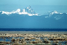
[5] The drainage basins of the Williamson and Sprague Rivers, in Oregon, are to the north and northeast of Upper Klamath Lake.
This lake existed up to 11,000 years ago at the end of the most recent ice age.
[16] Together, the four lower mainstem reservoirs total just 6.85 square miles (17.7 km2), or 0.04% of the Klamath River watershed.
The largest population centers include Klamath Falls, Oregon (19,462) and Yreka, California (7,290).
Nearly half of irrigated land utilizes water from the Bureau of Reclamation’s Klamath Project.