Lake of the Woods County, Minnesota
[2] The county contains the Northwest Angle, the northernmost point of the Lower 48 States, and the U.S. portion of Lake of the Woods, shared with Canada.
Jacques de Noyon, a Frenchman who came from Trois Rivières, Quebec, explored the area in 1688 and was the first European to see the lake.
In 1885 the region got its first settler, Wilhelm Zippel, a German immigrant and fisherman.
He settled on the lake's south shore in a place now called Zippel Bay.
The northern part of the county (the Northwest Angle) is separated from the rest of the county by the lake and thus has no land contact with the rest of the United States, making the Northwest Angle an exclave.
[8] Its highest point is a small protuberance one mile (1.6 km) west of Norris Camp,[7] at 1,316 ft (401 m) ASL.
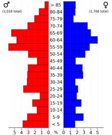
99.0% of residents were born in the United States, and 98.8% spoken only English at home.
[citation needed] Lake of the Woods County favored Democrats in every election from 1932 to 1976, typically by large margins, with the exception of the 1972 landslide victory of Richard Nixon.
Beginning in 1980, the county has voted Republican in every election except for 1992 and 1996, both wins by Bill Clinton, who won by less than 4% in the county and failed to obtain a majority of the vote both times thanks in part to the strong third-party performance of Ross Perot.
With the exception of the landslide wins of Franklin D. Roosevelt in 1936 and Lyndon B. Johnson in 1964, no candidate of any party had won over 65% of the vote in Lake of the Woods County from its founding through 2012.