Lincoln National Forest
Scattered throughout south-central New Mexico, these individual units contained lands in the Guadalupe, Sacramento, Sierra Blanca/White Mountains, Capitan and Gallinas ranges, and encompassed environments from the desert shrubs at the floor of the Chihuahuan Desert through forests of Piñon, Pine and Juniper to sub-alpine grasslands above the tree-line.
As a result of this order, the main elements of the Alamo National Forest, the public lands around the Sacramento and Guadalupe Mountains, were transferred to the Lincoln, greatly expanding its size.
These included the La Luz, Mayhill, and Weed Ranger Districts, all of which administered lands around their respective villages.
Located immediately south of the Mescalero Apache Reservation, which covers the northern half of the mountains, the district is primarily composed of Douglas Fir, Ponderosa pine, aspen, and oak, as well as numerous creeks and waterfalls.
A genuine engineering marvel, the Alamogordo and Sacramento Mountain Railway climbed 4,747 feet over 32 miles of track, and included numerous switchbacks, trestles, and grades as high as 6.4%.
423,416 acres in size, and ranging in elevation from 5,400 to 11,580 feet in the Capitan Mountains, the Smoky Bear district embraces a number of different environments, and includes desert shrubs, forests of pinyon pine, juniper, and spruce, and high-elevation grasslands above the treeline.
Rescued from a burnt tree by either a New Mexico Department of Game and Fish ranger or a group of soldiers from nearby Fort Bliss seconded to fight the blaze, the cub was flown to Santa Fe by New Mexico Ranger Ray Bell for treatment of burns and other injuries.
One of the major events in the war took place in the village of Lincoln itself, when forces supporting Sheriff George W. Peppin besieged the house of merchant Alexander McSween over several days while soldiers from nearby Fort Stanton stood by.
McSween was killed by gunfire, but a number of his supporters, known as "regulators," escaped, led from the burning building by a young tough named William Bonney, later known as the famous gunfighter Billy the Kid.
Of the sixteen fire lookout structures once in the forest, 9 are still extant, and six of those are listed on the National Register of Historic Places (NRHP).
The structures range from the unique stone structure of the Montjeau Lookout, a 1930s Civilian Conservation Corps (CCC) project in the Smoky Bear Ranger District, to the Sacramento Lookout, a 14x14 live-in cab on a 62-foot high steel tower located west of Cloudcroft, to the 7x7 ft.
Over the last one hundred years the use of public lands for grazing has proved to be a stable and consistent addition to the local economy.
As an example, a study by the Cooperative Extension Service at New Mexico State University, demonstrated that between 1970 and 2003 the average number of calves on forest lands was 6,233 head.
In terms of total economic impact, the massive diminution of consumptive activities on the Lincoln since 1990 has cost the region $14.7 million in potential revenues, comparable to the estimated income of 930 local residents.
Since the extension of rail lines, and later highways, into southern New Mexico in the late 19th/early 20th centuries tourism has been a consistent part of the economics of the Lincoln.
[20] While the debates on forest planning and operations are often defined by the tension between these various uses—grazing, logging, and dispersed recreation—studies, such as the NMSU paper quoted above, have shown that no one industry can produce enough economic benefit for the region to offset the loss of revenues implied by the removal of one or both of the other two.
[21] Along with collecting firewood, another long-standing tradition in the Lincoln National Forest is the cutting of Christmas trees during the holiday season.
Many of these trails explore small canyons, lead to natural features, such as waterfalls and springs, and follow the abandoned beds of the railroads that once hauled timber from the high forests down the desert floor.
These trails can be found in all parts of the district, from the deep canyons in the south to the rolling hills further north and range from easy to difficult.
[33] Totally undeveloped, these areas have no amenities and require hikers and backpackers to practice "Leave No Trace" camping techniques.
Not all forest lands are open to dispersed camping, so visitors should consult the current Motor Vehicle Use Map for the specific Ranger District to find eligible areas.
[38] While there are no designated equestrian campgrounds, pack and saddle animals are allowed on the vast majority of trails within the forest.
[31] The roads and developed trails of the Lincoln National Forest are popular areas for Off-Highway Vehicles (OHVs), such as motorcycles and ATVs.
Riders should consult the current Motor Vehicle User Map to see which forest roads are open to OHVs.
[39] Winter in southern New Mexico brings new recreational opportunities to all parts of the Lincoln National Forest from the dry, desert lowlands to the snowy, high mountain areas.
[46] Primarily a day-use area, the park does have limited opportunities for backpacking on the high ridges west of the cavern's entrance.
Established in 1970, GMNP protects Guadalupe Peak and El Capitan, the two tallest mountains in the state, as well as scenic McKittrick Canyon, known for its fall colors.
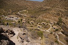
Shorter trips lead to a number of historical areas, such as the Butterfield Stagecoach station near Pine Springs, while longer treks climb high into the mountains and far into the adjacent salt-flats.
One of the more popular hikes is the 4.5 mile trail to the top of Guadalupe Peak, where decades of climbers have signed the register book at the summit.
For campers, GMNP has two developed campgrounds, one at Pine Springs, near the park headquarters on U.S. 62/180 and Dog Canyon, on the New Mexico side, approximately 70 miles west of Carlsbad.