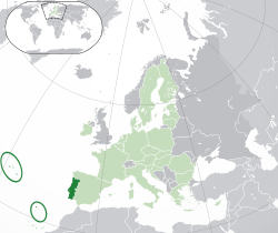
Outline of Portugal
[1] It is the westernmost country of continental Europe and is bordered by the Atlantic Ocean to the west and south and by Spain to the north and east.
The Muslim Moors arrived in the early 8th century and conquered the Christian Germanic kingdoms, eventually occupying most of the Iberian Peninsula.
During the 15th and 16th centuries, with a global empire that included possessions in Africa, Asia and South America, Portugal was one of the world's major economic, political, and cultural powers.
In the 19th century, armed conflict with French and Spanish invading forces and the loss of its largest territorial possession abroad, Brazil, disrupted political stability and potential economic growth.
After the Portuguese Colonial War (1961–1974) and the Carnation Revolution coup d'état in 1974, the ruling regime was deposed in Lisbon, a democracy was established and the country handed over its last overseas provinces in Africa.