Liu Hui
[2] He was a descendant of the Marquis of Zixiang of the Eastern Han dynasty and lived in the state of Cao Wei during the Three Kingdoms period (220–280 CE) of China.
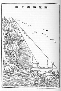
In his other work, Haidao Suanjing (The Sea Island Mathematical Manual), he wrote about geometrical problems and their application to surveying.
[13] This smaller work outlined instructions on how to measure distances and heights with "tall surveyor's poles and horizontal bars fixed at right angles to them".
The cartographer and state minister Pei Xiu (224–271) outlined the advancements of cartography, surveying, and mathematics up until his time.
This included the first use of a rectangular grid and graduated scale for accurate measurement of distances on representative terrain maps.