Pei Xiu
Pei Xiu (224–3 April 271), courtesy name Jiyan, was a Chinese cartographer, geographer, politician, and writer of the state of Cao Wei during the late Three Kingdoms period and Jin dynasty of China.
Following Sima Yan taking the throne of the newly established Jin dynasty, he and Jia Chong had Cao Huan deprived of his position to accord to the will of heaven.
[8] Historian Howard Nelson asserts that there is ample written evidence that Pei Xiu derived the idea of the grid reference from the map of Zhang Heng (78–139 CE), a polymath inventor and statesman of the Eastern Han period.
[13] Yet the oldest existing terrain maps from China date to the fourth century BCE, found in a Qin tomb in present-day Gansu in 1986.
[14] In 1697, the Qing dynasty cartographer Hu Wei (胡渭) reconstructed Pei Xiu's maps in his Yugong Zhuizhi (禹貢錐指, A Few Points on the Vast Subject of the Yu Gong).
[18]Pei Xiu continues his preface with short background information on the conquests by the Jin dynasty and the impressive maps commissioned by Sima Zhao (211–264).
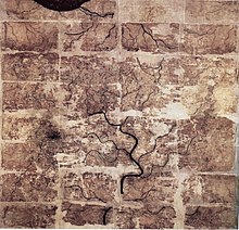
After Shu had been conquered and the maps were examined, with regard to the distances from one another of mountains, rivers, and places, the positions of plains and declivities, and the lines of the roads, whether straight or curved, which the six armies had followed; it was found that there was not the slightest error.
Now, referring back to antiquity, I have examined according to the Yu Gong the mountains and lakes, the courses of the rivers, the plateaus and plains, the slopes and marshes, the limits of the nine ancient provinces and the sixteen modern ones, taking account of commanderies and fiefs, prefectures and cities, and not forgetting the names of places where the ancient kingdoms concluded treaties or held meetings; and lastly, inserting the roads, paths and navigable waters, I have made this map in eighteen sheets.
If one has graduated divisions, but no rectangular grid or network of lines, then while one may attain accuracy in one corner of the map, one will certainly lose it elsewhere (i.e. in the middle, far from guiding marks).
If one has a rectangular grid, but has not worked upon the [third] principle, then when it is a case of places in difficult country, among mountains, lakes or seas (which cannot be traversed directly by the surveyor), one cannot ascertain how they are related to one another.
So also the reality of the relative positions is attained by the use of paced sides of right-angled triangles; and the true scale of degrees and figures is reproduced by the determinations of high and low, angular dimensions, and curved or straight lines.
Thus even if there are great obstacles in the shape of high mountains or vast lakes, huge distances or strange places, necessitating climbs and descents, retracting of steps or detours — everything can be taken into account and determined.