Lockyer Creek
Rising on the eastern slopes of the Great Dividing Range, the creek flows generally north-easterly for more than 100 kilometres (62 mi) before it reaches its confluence with the Brisbane River north-northeast of Lowood, and downstream from the Wivenhoe Dam.
Approximately 5 kilometres (3.1 mi) upstream from the junction of Lockyer Creek and the Brisbane River is the Wivenhoe Dam.
The poor conditions have resulted in unstable stream banks and gully erosion from the removal of riparian vegetation.
[8] The Bureau of Meteorology recorded a rise of 8 metres (26 ft) in 23 minutes during the flash flood but initially dismissed the reading as a fault.
[9] Water rose approximately 9 feet (2.7 m) above the 1893 flood level recorded at the Lockyer Creek Railway bridge (see below).
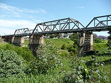
[16] Further downstream in the district of Clarendon, an earlier railway structure (1885) built of timber piles with a deck of iron trusses, is possibly as spectacular.