Luitpold Tower
The leadership of the PWV took over the coordination of the project, had the plans produced by architect Ludwig Ullmann and gathered the necessary funding, predominantly from membership subscriptions.
The upper portion of the tower is occupied by a spacious room with a relatively narrow, metallic spiral staircase in the centre, leading to the top.
The visitor leaves the staircase turret through a metal door and finally enters the viewing platform, which is surrounded by a sandstone balustrade, approximately waist high, with four observation niches.
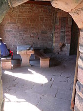
It contains a stone table and benches, a fireplace and a plaque on which essential data about the tower and its architectural history are documented.
"[7] The tower stands on the territory of the municipality of Merzalben in the middle of the Palatine Forest at the highest point of the Weißenberg (610 m above sea level (NN)).
In good weather 457 named places can be identified: in the Palatinate, in the state of Baden-Württemberg, in French Alsace and the Saarland,[8] and the viewing platform has 12 direction tables that enable easy orientation.
In good conditions, for example, the following may be seen: the Donnersberg (highest peak in the Palatinate region, 42 km distant, visibility ca.