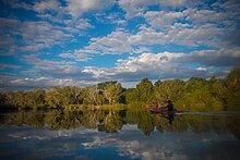
Lugenda River
It flows in a south-north direction from Lake Amaramba/Lake Chiuta and is the largest tributary of the Ruvuma River.
The Lugenda River and Mecula Mountain are thus the important tourist destinations in Mozambique's northern province.
On the east, its flow is through rocky gorge with the entire river vanishing into "slot canyons" displaying broad sandy waterways.
Most of the basin area of the river lies in the Niassa Province where the irrigation potential is reported to be 200,000 hectares (490,000 acres).
[1] The river valley has fertile alluvial soil with good water resources as it is fed by many perennial streams on both banks.
[10] The river valley, and the Niassa Wild Life Preserve enclosed within it, has a history linked to World War I. Germans, under the command of General Von Lettow-Vorbeck, crossed the Ruvuma River at Negomano and entered the Portuguese held Mozambique in search of food for his troops.
One of the battalions dispatched towards the Mecula Mountain in search of food had to fight a fierce battle with the Portuguese.
Witnesses to this battle are seen in the form of a few graves on the hill slopes at Mecula, the district capital of Niassa.
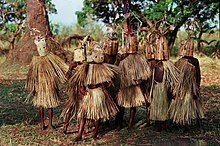
This route is being developed for game and ecotourism envisaging fishing, wildlife viewing, boat rides and so forth.
[11] Lugenda Wilderness Camp, which is part of the Wildlife Preserve, is on the eastern bank of the Lugenda river, amongst the Ngalongue Mountains (inselbergs); inselberg is a common international term used to define isolated rock hill, knob, ridge, or small mountain that rises abruptly from a gently sloping or virtually level surrounding plain.
[14] At the eastern edge of the river, the camp has dirt roads, fairly well maintained for the purpose of safari tours to facilitate wild life tracking.
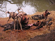
[16] Niassa Reserve, named after the province where it is situated, covers an area of 45,000 square kilometres (17,000 sq mi).
The mountainous forests of the preserve harbour a large number of silver hornbills, buffalo and herds of wild elephants.