Lunae Palus quadrangle
The quadrangle covers the area from 45° to 90° west longitude and 0° to 30° north latitude on Mars.
There would be a hard crust on the top of the soil similar to a deposit, called caliche which is common in the U.S.
[4][5] Such crusts are formed by solutions of minerals moving up through soil and evaporating at the surface.
The tested soil contained abundant silicon and iron, along with significant amounts of magnesium, aluminum, sulfur, calcium, and titanium.
Some chemicals in the soil contained sulfur and chlorine that were like those remaining after the evaporation of sea water.
[9] Using results from the chemical measurements, mineral models suggest that the soil could be a mixture of about 80% iron-rich clay, about 10% magnesium sulfate (kieserite?
The study's authors found that perchlorate will destroy organics when heated and will produce chloromethane and dichloromethane, the identical chlorine compounds discovered by both Viking landers when they performed the same tests on Mars.
Because perchlorate would have broken down any Martian organics, the question of whether or not Viking found life is still wide open.
One aim of the Mars Science Laboratory is to search for signs of ancient life, as many Martian rocks occur in a context of hydrogeology, that is, they were formed in water, at the bottom of lakes or seas, or by water percolating through the soil, although Brown University researchers have recently suggested outgassing of steam to atmosphere from a new planet's interior can also produce the clay minerals seen in these rocks.
To bring the craft down safely, a 12-mile wide, smooth, flat circle was needed.
The site eventually settled on for the Mars Science Laboratory was Gale Crater in the Aeolis quadrangle, and a successful landing took place there in 2012.
NASA scientists believe Gale Crater's floor rocks are indeed sedimentary, formed in pooled water.
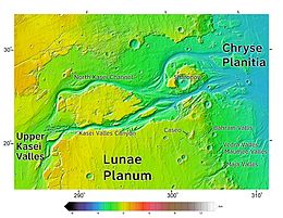
[20] One of the most significant features of the Lunae Palus region, Kasei Valles, is one of the largest outflow channels on Mars.
It begins in Echus Chasma, near Valles Marineris, and empties into Chryse Planitia, not far from where Viking 1 landed.
Sacra Mensa, a large tableland, divides Kasei into northern and southern channels.
Large troughs (long narrow depressions) are called fossae in the geographical language used for Mars.