Macanal Formation
The predominantly organic shale formation dates to the Early Cretaceous period; Berriasian to Valanginian epochs and has a maximum thickness of 2,935 metres (9,629 ft).
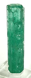
The formation is a source rock for oil and gas in the Eastern Cordillera Basin and adjacent Llanos Basin foothills and provides emeralds in the vicinity of Macanal, after which the formation is named.
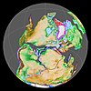
[10] The formation has been deposited in a shallow marine environment in an enclosed basin,[5] with as provenance areas the Santander High and the Guiana Shield.
[14] Analysis of the deformation registered in ammonite fossils has helped in understanding the tectonic history of the Llanos foothills of the Eastern Ranges.
[15] The Macanal Formation is apart from its type locality in the Batá River canyon,[16][17] found in the Cravo Sur anticline, east of the Ocetá Páramo,[18] in the Desespero Synclinal in the southern and northern parts of Labranzagrande,[19][20] around Páez and Campohermoso,[17] in the eastern part of Gama, bordering the Guavio Reservoir,[21] and in the Servitá Synclinal, west of Villavicencio.
[22] The Macanal Formation crops out along the road between Bogotá and Villavicencio and is there heavily fractured and folded.
[29] The Servitá Fault forms the contact between the Guatiquía Redbeds and the Macanal Formation,[30] and the Upín Fault, part of the same system puts the Macanal Formation in contact with the Tertiary Palmichal Group.