Mackinaw City, Michigan
Mackinaw City (/ˈmækənɔː/ MAK-ə-naw) is a village at the northernmost point of the Lower Peninsula of Michigan, United States.
Mackinaw City and St. Ignace also serve as access points for ferries to and from Mackinac Island.
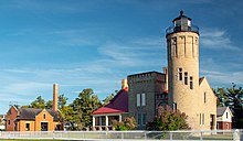
The Mackinaw City area is home to a number of historic sites, including Fort Michilimackinac, Historic Mill Creek State Park, Old Mackinac Point Light, McGulpin Point Light, and the retired US Coast Guard Icebreaker Mackinaw.The name of Mackinaw is a respelling of "Mackinac", a strait between Lake Huron and Lake Michigan, an island in the strait, and an important trading-post on the island; ultimately from Ojibwe mishinii-makinaang (“at the place of many snapping turtles”).
[5] The predominant historic tribes in this area were three Algonquian peoples, known collectively as the Council of Three Fires: Ojibwe (Chippewa), Ottawa (Odawa), and Potawatomi at the time of French contact in the 17th century.
These peoples had long frequented the surrounding region, which they called Michilimackinac, to fish, hunt, trade, and worship.
The first European to pass the site of Mackinaw City was Jean Nicolet, sent out from Quebec City by Samuel Champlain in 1633 to explore and map the western Great Lakes, and to establish new contacts and trading partnerships with the Indian tribes of the region.
[6] His reports resulted in the French government providing funds to send settlers, missionaries, traders, and soldiers to the Great Lakes region.
Father Jacques Marquette had established a mission on Mackinac Island in 1671 (which was shortly thereafter moved to St. Ignace on the Michigan peninsula, where it remained active until 1705).
The construction of Fort de Buade at St. Ignace in 1681 was an attempt by the authorities of New France to establish a military presence at the Straits, but it closed in 1697.
It housed French civilians inside the fort, and allowed them to garden, hunt, and fish outside the walls.
Europeans, in the form of French and Scots-Irish traders from Detroit and elsewhere, did not return until the following spring, with the understanding that they would trade more fairly with the Native Americans.
The original plan reserved the northern portion as a park, to preserve the area that was once Fort Michilimackinac and to accommodate a hoped-for lighthouse.
During the second half of the 1800s, the Mackinaw area (and northern Michigan in general) saw an increase in summer resort tourism.
Old Mackinac Point Lighthouse began operation in 1889 and the adjacent Fog Signal Building was built in 1906.
At the same time, a grant was provided to the Mackinac Island State Park Commission, which owned the property at the Bridge's southern terminus, to begin archeological excavations of the Michilimackinac ruins.
Through the course of time, the main industry of Mackinaw City became almost strictly tourist-oriented, with other major sources of employment being civic services such as mail, police, firefighting, schooling, and so on.
[1] The village of Mackinaw City includes the northernmost point of Michigan's Lower Peninsula.
The southern approach of the Mackinac Bridge is located within Mackinaw City, bisecting the village.
The New York Central's Michigan Central subsidiary, the Pennsylvania Railroad's Grand Rapids and Indiana Railroad subsidiary, and other rail lines provided passenger traffic on trains such as the Northern Arrow to Mackinaw City.
It was rededicated in 2008 as the North Central State Trail, providing a public right-of-way from Mackinaw City to Gaylord.