Manville, New Jersey
The borough is located in the heart of the Raritan Valley region and is a part of the New York metropolitan area.
[22] Manville was named after the Johns-Manville Corporation, which maintained a large manufacturing facility in the borough for decades.
[1][2] Unincorporated communities, localities and place names located partially or completely within the borough include Millsboro.
[7] The borough form of government used by Manville is a "weak mayor / strong council" government in which council members act as the legislative body with the mayor presiding at meetings and voting only in the event of a tie.
The mayor can veto ordinances subject to an override by a two-thirds majority vote of the council.
[36][37] As of 2024[update], the mayor of Manville is Independent Richard M. Onderko, whose term of office ends December 31, 2027.
[46] For the 119th United States Congress, New Jersey's 12th congressional district is represented by Bonnie Watson Coleman (D, Ewing Township).
[67] Among the borough's 2010 Census population, 50.3% (vs. 60.4% in Somerset County) were registered to vote, including 63.0% of those ages 18 and over (vs. 80.4% countywide).
[84][85][86] Christ the King School, which opened in 1968 and served students in grades Pre-K–8, was closed by the Roman Catholic Diocese of Metuchen at the end of the 2014–2015 school year in the wake of declining enrollment that had resulted in a $1 million deficit to the parish in the preceding five years.
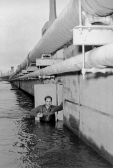
[92] Manville suffers from occasional flooding events that occur after prolonged heavy rainfall events, when the Raritan River and Millstone River overflow their banks into the northern section (Raritan) and the Lost Valley section (Millstone) of the borough.
The southern parts of Main Street also suffer from the flooding, due to the presence of Royce Brook which backs up with water from the nearby Millstone River in which it empties.
There are studies being undertaken to address the flooding problems in the Millstone River basin and Manville; however, none of the flood control ideas in the Millstone River basin have gotten beyond the initial study stages as of late 2006.
[93] Manville was severely hit by a flood in the wake of Hurricane Floyd in September 1999, which dropped 10 to 12 inches (250 to 300 mm) of rain in the areas surrounding the borough.
There was also a large amount of fuel oil floating on the flood water which further damaged homes, many of which came off their foundations.
A portion of the north side received water coming from the Raritan at Dukes Parkway.
The problem was doubled in the Lost Valley section, as flood waters backed up where the Raritan and Millstone rivers meet near the dam.
Through research of Manville's history, Lost Valley was to remain open land due to the high risk of flood.
Another severe and devastating flood event occurred in Lost Valley during the April 2007 Nor'easter.
More extensive flooding affected Manville in August 2011 when Hurricane Irene passed through New Jersey.
[96] On September 1, 2021, the tropical remains of Hurricane Ida swept through Manville, causing floods in the majority of the town.
[98] That night, a local banquet hall, The Saffron, exploded and burned to the ground early Friday morning.
The National Oceanic and Atmospheric Administration provides access to real time river level data.