Mao Kun map
It is the earliest known Chinese map to give an adequate representation of Southern Asia, Persia, Arabia and East Africa.
Duyvendak to have been part of the library of Mao Kun, a collector of military and naval material, who might have acquired it while he was the governor of Fujian.
The map, after Nanjing and the Yangtze River, shows mainly the coastal regions and islands along the sea route, and places are depicted in their approximate positions along the contour of the coast.
The coast of the main land mass is shown largely as a continuous irregular line at the top of the map, with deep V-shaped indentations indicating river estuaries.
As a result of the nature of the map and its focus on the coastal region, the shape of the Malay Peninsula cannot be distinguished, and India became elongated as its interior is omitted.
Pages of the map are arranged from right to left in traditional Chinese book format, starting from Nanjing and finishing in Hormuz.
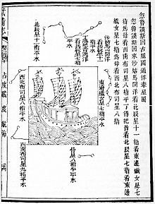
Four stellar diagrams are given at the end with instruction for positioning the ships in relation to the stars and constellations to ensure correct navigation in two passages – between Sumatra and Sri Lanka, and between Hormuz and Calicut.
[2] The structure of the last portion or most western of the chart suggests that it may have been composed from a number of other maps of varying scales, including one that was just for Sri Lanka, another for the Maldives and a third for the African Coast.
This route from the South China Sea through the Strait of Malacca therefore shows greater details on the places of Indochina, the Malay Peninsula and Sumatra.
[18] Among the places marked on the map are Chenla (占羅), Champa (占城), Siam (暹羅), Langkasuka (狼西加), Singapore (as Temasek, 淡馬錫), Malacca (滿剌加), Penang (梹榔嶼), Langkawi (龍牙交椅), Sumatra, and Kalimantan.
This proposal also suggests that the Zheng He voyages never traveled more than six degrees south of the Equator, which would explain the omission of the important trading center of Kilwa in Southern Tanzania.
The Pirates of the Caribbean franchise featured a map with circular rotating rings that led to spiritual realms and legends of the land beyond death.