Cartography of China
Chinese cartography began in the 5th century BC during the Warring States period when cartographers started to make maps of the Earth's surface.
There is an ancient Chinese legend called He Bo Xian Tu (河伯獻圖), which roughly means "the River Deity presenting a map".
During the mythical Xia dynasty, a river deity gave Yu the Great a stone with a flood map etched on its surface.
The earliest reference to a map in Chinese history can be found in Volume 86 of the historical text Records of the Grand Historian (Shi Ji).
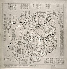
The three silk maps found at the Mawangdui tumulus in Changsha, Hunan Province are traced back to the 2nd century BC.
Although the military map does not contain names, a legend, scales, or any form of explanatory text, it shows modern Hunan, Guangdong and Guangxi provinces, as well as the boundary between the Han Empire and Nanyue Kingdom, covering the area from 111°E to 112°30′E, and from 23°N to 26°N.
However, they were superseded in 1986 after Qin dynasty maps dating back to the 4th century BC were found in Fangmatan, Tianshui, Gansu Province.
[12] After the founding of the Yuan dynasty in 1271, Kublai Khan ordered the compilation of a geography monograph named Dayuan Dayitong Zhi (大元大一統志) (extant manuscripts lack maps) in 1285.
An extant map attached to the Jingshi Dadian (經世大典; 1329–1333) proves Mongols' accurate knowledge on Inner Asia that was obtained from Muslims.
Influences by these official projects, Taoist monk Zhu Siben (朱思本) compiled a geography monograph of China named Jiuyu Zhi (九域志) in 1297.
Newly discovered materials reveal personal networks among intellectuals of southern China, centered in Qingyuan (Ningbo).
In addition, Ningbo was one of the most important seaports and the sea routes were extended to Fuzhou and Guangzhou, and Southeast Asia, Japan and Goryeo.
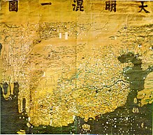
The Shengjiao Guangbei Tu ("map of the resounding teaching (of the khan) prevailing all over the world") by Li Zemin is lost.
However, the Shuidong Riji (水東日記) by the Ming period book collector Ye Sheng (葉盛) (1420–1474) includes a modified edition of the map by the name of Guanglun Jiangli Tu (廣輪疆理圖).
But contrary to Song period maps which reflected limited Chinese knowledge on geography, it incorporated information on Mongolia and Southeast Asia.
In 1579, Luo Hongxian published the Guang Yu Tu (廣與圖) atlas, which includes more than 40 maps, a grid system, and a systematic way of representing major geographical features such as mountains, rivers, roads and borders.
The Guang Yu Tu incorporates the discoveries of admiral Zheng He's 15th century voyages along the coasts of China, Southeast Asia, India, and East Africa.
Between 1405 and 1433, the Ming government sponsored Zheng He to go on a series of seven naval expeditions to places in the South China Sea, Indian Ocean, and beyond.
It also exhibited some special characteristics in terms of how its contents are presented: Chinese traditional cartography skills became more developed and advanced in the late Ming dynasty under the influence of new ideas of technology and studies of natural science, which were introduced from the West to China.
Gridlines are not used on either Yu Shi's Gujin xingsheng zhi tu (1555) or Zhang Huang's Tushu bian (1613); instead, illustrations and annotations show mythical places, exotic foreign peoples, administrative changes and the deeds of historic and legendary heroes.
It depicts the general form of the Old World, placing China in the center and stretching northward to Mongolia, southward to Java, eastward to central Japan, and westward to Africa and Europe.
The Selden Map of China, which dates from the early 17th century and shows a series of precisely plotted maritime routes, has provoked a reassessment of the global significance of Ming cartography.
[18] As Soviet influence waned in the 1960s, geographic activity continued as part of the process of modernisation until it came to a stop with the 1967 Cultural Revolution.