History of the mapping of California
Exploration of California by Europeans began in 1542 with Juan Rodríguez Cabrillo of Spain.
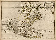
One of the most famous cartographic errors in history, it was propagated on many maps during the 17th and 18th centuries, despite contradictory evidence from various explorers.
[6] The legend was initially infused with the idea that California was a terrestrial paradise, like the Garden of Eden or Atlantis.
[10] In 1841, Cadwalader Ringgold, an officer in the United States Navy, spent twenty days surveying the San Francisco Bay watershed as a member of the United States Exploring Expedition In 1849, Cadwalader Ringgold began a more comprehensive survey the San Francisco Bay region,[11] the Sacramento River, and parts of the American and created several maps which included depth sounding information for the Sacramento River and San Francisco Bay.
This book includes the maps from the 1849 expedition and color illustrations of ports and important landmarks.
[13] In 1857, the commanding officer of the United States Coast Survey Steamer, Active, discovered a deep submarine valley, or "gulch", in the center of Monterey Bay.
The 262-page volume is complete with illustrations, coordinate tables, notes on magnetic variation, and some bathymetric sounding information.
Many organizations and government agencies are involved in collecting and mapping data in California today.