Mazaruni River
Its source is in the remote western forests of the Pakaraima Mountains and its confluence with the Cuyuni River is near Bartica.
In 1992, a joint expedition of the Guyana Defence Force and Welsh Guards members was unable to reach the source of Mazaruni River, even with training, finances and equipment.
The next is near village of Imbaimadai and the last set is below the village of Kamarang where the Mazaruni River tumbles through last few major falls, the first of which is a few kilometres long gutter known as Chitigokein Falls, which finishes in Coffy pool, a deep pool named after Mehir "Cousin Body" Coffy, one of the last pork-knockers (small-scale diamond and gold miners) of Guyana.
After few kilometres of relatively calm water, the last set of great Mazaruni River Falls begin.
The most abundant are the large and dangerous black electric eels (numfish), piry (relative of piranha cutleback), haimara, and baiara.
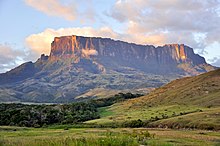
[3] The Mazaruni River flows over three distinct habitats; the flat tops of Roraima Plateau, known in Venezuela as “tepuis”, the lower two plateaus and the low lands.
In the upper Mazaruni River basin, in 1890, near Isseneru village, first alluvial diamonds were found in Guyana.
[4] The discovery was made accidentally by Edward Gilkes, was prospecting for gold along the Putareng Creek, a small left hand tributary of the Mazaruni River.
Some places, such as Imbaimadai, Kamarang, Aruwai, Tiboku, Kaburi and Marshal Falls produced a large amount of alluvial gold during golden era of river dredging (1980–1995).