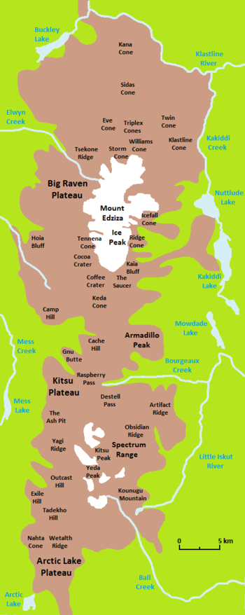
Kitsu Plateau
Access to this remote plateau is mainly by aircraft since motorized vehicles are prohibited from entering Mount Edziza Provincial Park.
[2][3] The volcanic complex consists of a group of overlapping shield volcanoes, stratovolcanoes, lava domes and cinder cones that have formed over the last 7.5 million years.
[6] As a part of the Mount Edziza volcanic complex, the Kitsu Plateau is drained entirely by streams within the Stikine River watershed.
[2] The plateau surface is barren of vegetation, but at lower elevations the surrounding valleys contain white spruce, lodgepole pine and trembling aspen forests.
[16] It lies on the steep southern slope of the Kitsu Plateau inside Nagha Creek valley and has been described as a pyroclastic cone or a conical explosion crater.
[19] More than 180 m (590 ft) of Raspberry lava flows are exposed in the Mess Creek Escarpment, most of which were erupted from a shield volcano that formed on a Late Miocene erosion surface.
[20][21] These lava flows travelled westward into the ancestral valley of Mess Creek and originated from vents north of Raspberry Pass which were subsequently buried under younger volcanic deposits.
The source of these flows was probably a cluster of vents further to the north called Sezill Volcano which may have been active prior to the onset of Armadillo volcanism.
[22] In contrast, the interbedded air-fall pumice and ash flows probably originated from the more than 4 km (2.5 mi) in diameter Armadillo Peak caldera northeast of the Kitsu Plateau.
[24] Lava from the Swarm Peak eruptive centre is exposed along the Mess Creek Escarpment where it overlies till and glacial-fluvial gravel derived from the Armadillo Formation.
[3][30] This is a Paleozoic and Mesozoic suite of volcanic, sedimentary and metamorphic rocks that accreted to the continental margin of North America during the Jurassic.
[1][33][34] The Kitsu Plateau lies at the southern end of Mount Edziza Provincial Park, a protected area founded in 1972 to showcase the volcanic landscape.
[14][35] Hunting, camping, fishing, hiking, wildlife viewing and nature studying are some of the activities available in Mount Edziza Provincial Park.
[14] Wildlife in the area includes moose, caribou, mountain goats, stone sheep, wolves, bears, squirrels, owls, ptarmigans, ravens, gyrfalcons, grouse and migratory songbirds.
[14] From near the Eastman Creek Rest Area south of Kinaskan Lake on the Stewart–Cassiar Highway, the historic Yukon Telegraph Trail extends about 15 km (9.3 mi) west to the Little Iskut River.
From there, it enters Mount Edziza Provincial Park and continues another 15 km (9.3 mi) west along Bourgeaux Creek through Raspberry Pass.