Mount Edziza volcanic complex
The Mount Edziza volcanic complex (/ədˈzaɪzə/ əd-ZY-zə; abbreviated MEVC) is a group of volcanoes and associated lava flows in northwestern British Columbia, Canada.
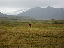
Warm summers and cold, snowy winters characterize the climate at the MEVC; snow and ice remain on the highest volcanoes year-round.
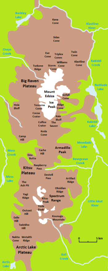
[26] It lies on the eastern edge of the Tahltan Highland, a southeast-trending upland area extending along the western side of the Stikine Plateau between the Boundary Ranges in the west and the head of the Iskut River in the east.
[10][27] The MEVC is in the Southern Boreal Plateau Ecosection which consists of several upland summits as well as wide river valleys and deeply incised plateaus.
[39] At the northwestern end of the Spectrum Range is the Kitsu Plateau; its dominant feature is the even smaller Mess Lake Lava Field which covers 18 km2 (6.9 sq mi).
[62] Several short tributaries of Mess Creek drain the western half of the MEVC where they have cut steep-sided canyons into the volcanic plateau.
Several species of birds are also present in the area, including scaup, owls, goldeneye, grebes, gyrfalcons, white-winged scoters, ravens, grouse and ptarmigans.
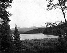
The Mess Creek, Kakiddi and Klastline valleys are intermixed with white spruce, trembling aspen and lodgepole pine, the latter two of which occur in drier areas.
[9] The MEVC was covered by a regional ice sheet during the Pleistocene which receded and advanced periodically until about 11,000 years ago when deglaciation was essentially complete in a steadily warming climate.
[90][91] This warming trend ceased about 2,600 years ago, causing glaciers to advance from Mount Edziza, Ice Peak, the Spectrum Range and the Armadillo Highlands as part of the neoglaciation.
The present trend towards a more moderate climate put an end to the neoglacial period in the 19th century, resulting in rapid glacial recession throughout the MEVC.
This rapid glacial recession is apparent from the lack of vegetation on the barren, rocky ground between the glaciers and their trim lines which are up to 2 km (1.2 mi) apart.
[92] The MEVC has been extensively modified by local and regional glaciations as evidenced by the existence of drumlins and glacial striations, which record ice movement to the north-northwest across the western portion of the plateau.
[93] Evidence of ice stagnation is present in the form of outflow channels, eskers, kames, kettles and morainal ridges on the northern side of the MEVC adjacent to Buckley Lake.
[65] The MEVC is part of the Northern Cordilleran Volcanic Province (NCVP), a broad area of shield volcanoes, lava domes, cinder cones and stratovolcanoes extending from northwestern British Columbia northwards through Yukon into easternmost Alaska.
[103] The dominant rocks comprising these volcanoes are alkali basalts and hawaiites, but nephelinite, basanite and peralkaline[a] phonolite, trachyte and comendite are locally abundant.
[111] MEVC hawaiites are thought to be the product of partial fractional crystallization[d] and the accumulation of feldspar inside rising columns of mantle-derived alkali basaltic magma.
[15][111][113] Underlying the MEVC is the Stikinia terrane, a Paleozoic and Mesozoic suite of volcanic and sedimentary rocks that accreted to the continental margin of North America during the Jurassic.
[7][148] The eruption sequence and style of the MEVC, along with its chemistry, mineralogy and isotopic composition, is similar to continental peralkaline volcanism at the Rainbow Range of central British Columbia, the Afar Depression of East Africa and parts of the Great Basin of the western United States.
Instead, a Holocene age is inferred because their eruptive products do not show evidence of having been glaciated by the Cordilleran Ice Sheet, which retreated from the area about 11,000 years ago.
[111] This includes the Pyramid, Ice Peak, Pillow Ridge, Edziza, Arctic Lake, Klastline and Big Raven formations which have all formed within the last two million years.
The Canadian National Seismograph Network has been established to monitor earthquakes throughout Canada, but it is too far away to provide an accurate indication of activity under the complex.
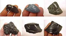
The obsidian from this portion of our territory provided us with weaponry, tools and trading goods that ensured our Tahltan people could thrive for thousands of years.
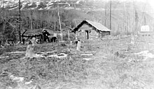
[9][26] This was a nearly 3,000 km (1,900 mi) long telegraphy system built by the Dominion Government Telegraph Service between 1897 and 1901 to send messages between Ashcroft, British Columbia in the south to Dawson City, Yukon in the north.
[16] It was identified by the mapping program of Operation Stikine in 1956 along with Level Mountain, the Iskut-Unuk River Cones and many smaller volcanoes in the Canadian Cordillera.
[10][58] A three-month period of earthquake monitoring was conducted at the MEVC in 1968 after geologists of the Geological Survey of Canada suggested that there may still be magma movement under the volcanic complex.
[178] By 1970, Souther and his assistant Maurice Lambert had established that episodic eruptions of alkali basalt and silicic peralkaline lavas had taken place at the MEVC over a timespan of at least 10 million years.
[189][191] The MEVC offers many recreational activities, including mountain climbing, camping, fishing, hunting, horseback riding, wildlife viewing, photography, hiking and backpacking.
[60] From near the Eastman Creek Rest Area south of Kinaskan Lake on the Stewart–Cassiar Highway, the historic Yukon Telegraph Trail extends about 15 km (9.3 mi) west to the Little Iskut River.
[193] From there, it enters Mount Edziza Provincial Park and continues another 15 km (9.3 mi) west along Bourgeaux Creek into the central portion of the MEVC at Raspberry Pass.