Meteorological history of Hurricane Gordon
[3] Spots of convection flared on the morning of November 9;[4] banding features appeared as its center made landfall on the northeastern Nicaraguan coast near Puerto Cabezas.
[5] A full day later a trough to the storm's northwest over the Gulf of Mexico moved the depression offshore,[6] to the northeast, and over the warm waters of the western Caribbean Sea.
[7] Lacking firm movement because of weak steering currents,[7] Gordon meandered north-northeast in the presence of mild west-southwesterly wind shear,[1][8][9] unable to strengthen under the adverse conditions.
Despite the warm waters, Gordon did not strengthen that day as strong upper-tropospheric shear hindered development,[13][14] disorganized the upper-level circulation, and reduced its winds to 40 mph (64 km/h).
[1] Continued shear prevented the upper-level development needed for typical cyclonic organization, but a strong lower-level circulation had formed.
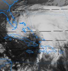
[20] Meanwhile, the broad-scale circulation that was covering most of the Caribbean Sea (of which Tropical Storm Gordon was only a part) was interacting with an upper-tropospheric trough near the Straits of Florida.
[1] When Gordon crossed eastern Cuba, the National Hurricane Center determined that it had become the most dominant of these low-level systems and had absorbed their convections.
[1][23]) By nightfall of November 13, Gordon had not only made two landfalls and survived interactions with three competing systems but also, in assimilating the Bahamian low, had gained the cool central core typical of a subtropical cyclone.
[34] After stalling offshore for almost a day, a mid- to upper-tropospheric trough over the central U.S. slowly pulled Tropical Storm Gordon northward then north-northeastward towards Florida's west coast.
[40] The shortwave trough that had been steering Gordon across Florida moved ahead of the storm and its influence was replaced by a mid-tropospheric ridge over the eastern United States.
[1][42][43] The hurricane's loop continued, and as it moved to a west-northwesterly heading Gordon briefly threatened North Carolina's Outer Banks[44] before stalling offshore once again.
[45] In the presence of weak steering currents once again, Gordon lost strength and slipped back to tropical storm status with 70 mph (110 km/h) winds.
[51] A high-pressure system over the central United States drifted east and added a westward component to Gordon's southward motion,[50] pulling the storm southwest towards Florida.
[53] The high pressure system over the continent continued pulling the depression towards the west[54][55] until it made its final landfall near Cape Canaveral that night with winds of 30 mph (48 km/h).
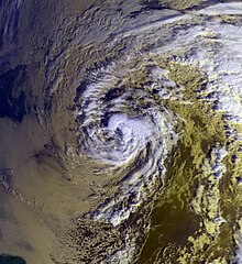
[60][61] The National Hurricane Center described the storm as "a complex system, [which] followed an unusual, erratic path over the western Caribbean Sea and islands, Florida and the southwestern Atlantic."