Ridge (meteorology)
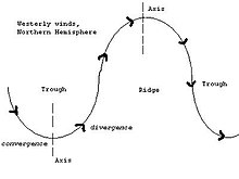
Ridges can be represented in two ways: Given the direction of the winds around an anticyclonic circulation and the fact that weather systems move from west to east:[2] Surface ridges, just like highs, generate fair weather because they develop under wind convergence in the negative vorticity advection zone ahead of the upper-level ridge.
[2] The vertical downward air motion then gives a divergence of the winds near the surface.
The subsidence of the air causes a warming in the column compared to the previous environment and therefore a drying of it because its relative humidity decreases, which has the effect of clearing the sky.
It is a series of ridges near the horse latitude characterized by mostly calm winds, which act to reduce air quality under its axis by causing fog overnight, and haze during daylight hours as a result of the stable atmosphere found near its location.
These blocks can remain in place for several days or even weeks, causing the areas affected by them to have the same kind of weather for an extended period of time (e.g. precipitation for some areas, clear skies for others).