1994 Atlantic hurricane season
The season officially started on June 1 and ended on November 30, dates which conventionally limit the period each year when most tropical cyclones tend to form in the Atlantic Ocean.
Hurricane Gordon was the most significant storm of the season, causing damage from Costa Rica to North Carolina among its six landfalls.
[7] The low seasonal activity is attributed to the presence of El Niño, which is a global coupled ocean-atmosphere phenomenon.
These dates conventionally delimit the period of each year when the majority of tropical cyclones tend to form in the Atlantic Ocean.
High pressures built to its north and east, causing the remnant tropical depression to stall over northwestern Georgia.
On July 20, the circulation became better organized as the convection increased; however, the depression moved ashore near Georgetown, South Carolina at 1400 UTC without intensifying beyond winds of 35 miles per hour (56 km/h).
[16] The remnant low continued northeastward across the northeastern United States, becoming unidentifiable on July 22 while entering Nova Scotia.
Although no fatalities were directly related to Beryl, several injuries were reported, including 37 due to an associated F3 tornado that touched down in Lexington, South Carolina.
[22] Hurricane Chris originated from a tropical wave that emerged from the west coast of Africa on August 11 and tracked westward.
The storm remained away from land, passing to the east of Bermuda on August 21, before it merged with an extratropical baroclinic zone to the southeast of Newfoundland.
Surface observations and ship reports suggested that it developed into Tropical Storm Debby on September 10, despite poor organization evidenced by satellite imagery.
Dvorak classifications began on September 21, and later that day the system developed into Tropical Depression Seven about 500 miles (800 km) southwest of Cape Verde.
The next morning, the storm attained its peak intensity, with winds of 60 mph (97 km/h) and a minimum atmospheric pressure of 997 mbar (hPa; 29.53 inHg).
[32] After peaking, Ernesto entered an area of increasing wind shear and stronger upper-tropospheric flow, resulting in a steady weakening trend.
[32] The last public advisory was issued on Tropical Depression Ernesto at 2100 UTC September 25,[33] although it did not dissipate until early the next day,[32] about 450 miles (720 km) west of Cape Verde.
The circulation was upgraded to the ninth depression of the 1994 season, 174 miles (280 km) southeast of Cape Verde the next day at 1200 UTC when banding cloud patterns became evident on satellite imagery.
A reconnaissance aircraft did not indicate a closed circulation due to the proximity with Cuba, which caused difficulties with satellite intensity estimates.
On September 30 at 0600 UTC, the tropical depression attained its peak intensity, winds had reached 35 mph (56 km/h) and the minimum central pressure had dropped down to 1004 mbar.
[41][42] The origins of Florence were traced back to an area of low pressure which developed in late October along a stationary front located 1,150 mi (1,850 km) east-southeast of Bermuda.
[46] By the afternoon of November 4, Florence completed its transition into a tropical cyclone and deep convection developed, causing the storm to quickly intensity; with winds increasing by 20 mph (32 km/h) in a 6-hour time period.
[47] Late on November 4, Florence was upgraded to a hurricane as a solid area of deep convection developed around the center of circulation.
[51] As the low moved further to the east, steering currents in the area of Florence weakened, leading to the storm stalling late on November 6.
[53] Later that morning, Florence had developed a large, 35 to 40 mi (56 to 64 km) wide eye and the forward motion continued to increase.
A strong extratropical cyclone located to the north of Florence was causing the storm to move towards the northwest at a rapid pace of 30 mph (48 km/h).
Hurricane Gordon caused heavy damage and 1,122 fatalities in Haiti; the storm's effects extended from Costa Rica to North Carolina in the United States.
Over Hispaniola, the persistent southerly flow to the east of the storm, combined with the steep upslope motion of the land, generated prolonged rainfall which triggered disastrous flooding and mudslides.
[63]On September 30, a weak and broad frontal low absorbed the remnants of Tropical Depression Ten in the southeastern Gulf of Mexico.
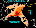
[64] In Florida, rough seas left minor coastal flooding and beach erosion, while also necessitating the rescue of 18 people from capsizing vessels.
[65] In South Carolina, up to 11.24 in (285 mm) of rain fell at Hilton Head Island,[64] damaging property and infrastructure in Beaufort County alone.
[65] After the season had officially ended, a Late December nor'easter developed from an area of low pressure in the southeast Gulf of Mexico.