Meteorological history of Hurricane Ivan
Over the subsequent days its intensity fluctuated largely due to eyewall replacement cycles, and Ivan passed just south of Jamaica, the Cayman Islands, and western Cuba with winds at or slightly below Category 5 status.
Turning northward and encountering unfavorable conditions, Ivan gradually weakened before making landfall just west of Gulf Shores, Alabama on September 16 with winds of 120 mph (190 km/h).
A tropical system along the wave axis contained a low pressure area as well as an impressive outflow pattern, though initially its convection was disorganized and limited.
After reaching hurricane status, Ivan began to rapidly intensify with continued favorable conditions, and in an 18‑hour period the pressure dropped 39 mbar (1.15 inHg) as the winds increased by 60 mph (97 km/h); early on September 6 Ivan attained an initial peak intensity of 135 mph (217 km/h) while located about 825 miles (1,328 km) east of the island of Tobago in the southern Lesser Antilles.
At the time, the hurricane maintained an eye diameter of 12 miles (19 km), with the northern portion of the eyewall producing strong winds on the island.
[1] Subsequently, it underwent an eyewall replacement cycle,[15] and for about 18 hours the intensity remained constant as it paralleled the northern coast of Venezuela offshore.
[16] After maintaining Category 5 status for about 12 hours, Ivan began a steady weakening trend due to another eyewall replacement cycle until reaching winds of 140 mph (230 km/h) on September 10.
However, weakening occurred again due to an eyewall replacement cycle, and at 0330 UTC on September 11 Ivan passed 23 miles (37 km) south of Portland Point, Jamaica, its closest approach, with winds of 150 mph (240 km/h).
[17] As it tracked further away from Jamaica, Ivan again rapidly intensified to Category 5 status, and early on September 12 it reached its peak intensity of 165 mph (266 km/h) with a pressure of 910 millibars (27 inHg).
[18] At 1415 UTC on September 12 Ivan passed 25 miles (40 km) south-southwest of George Town, Cayman Islands, where sustained winds of 150 mph (240 km/h) were reported.
[21] As Ivan gradually turned to the north, southwesterly flow from a large trough over the central United States increased wind shear over the hurricane.
[22] By late on September 14, the weakening trend ceased as the eyewall became better defined, and Ivan was expected to restrengthen slightly over an area of warmer water temperatures.
[24] As Ivan approached the Gulf Coast of the United States, Hurricane Hunters reported erosion of the southern portion of the eyewall,[25] and cooler waters just offshore contributed to further weakening.
Ivan accelerated to the northeast ahead of an approaching cold front, dropping heavy rainfall along its path and also producing a widespread tornado outbreak from Alabama through Maryland.
[1] By September 20, the system was located off the east coast of Florida, producing scattered thunderstorms; unfavorable wind shear prevented tropical redevelopment, though forecasters indicated the possibility for more favorable conditions a few days later.
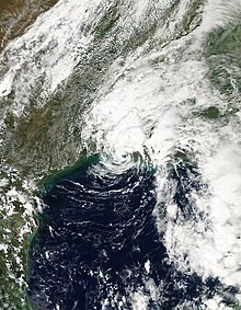
Based on reports from Hurricane Hunters, it is estimated the low redeveloped into Tropical Depression Ivan late on September 22, while located about 175 miles (282 km) south-southeast of the mouth of the Mississippi River.
"[29] Despite unfavorable shear and its disorganized cloud structure, the cyclone intensified to tropical storm status early on September 23, based on reports by Hurricane Hunters.
[32] However, the storm rapidly weakened over land, and by 1200 UTC on September 24, Ivan degenerated into a remnant low pressure area over southeast Texas.