Atlantic hurricane
They are organized systems of clouds and thunderstorms that originate over tropical or subtropical waters and have closed low-level circulation, and should not be confused with tornadoes, which are just another type of cyclone.
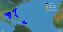
The United States National Hurricane Center (NHC) monitors tropical weather systems for the North Atlantic Basin and issues reports, watches, and warnings.
[7] Tropical cyclones are steered by flows surrounding them throughout the depth of the troposphere (the atmospheric layer ranging from the ground to about eight miles (13 km) high).
If the subtropical ridge is weakened by an upper trough, a tropical cyclone may turn poleward (north) and then recurve[9] (curve back toward the northeast into the main belt of the westerlies).
Poleward of the subtropical ridge, westerly winds prevail and generally move tropical cyclones that reach northern latitudes toward the east.
[10] The intensity of a tropical cyclone is generally determined by either a storm's maximum sustained winds or its lowest barometric pressure.
[18] The tenth place for the most intense Atlantic tropical cyclone is Hurricane Maria, which is listed to have deepened to a pressure as low as 908 mbar (26.81 inHg).
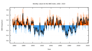
[22] There is a strong correlation between the amount of Atlantic hurricane activity in the tropics and the presence of an El Niño or La Niña in the Pacific Ocean.
During the quiescent periods (3000–1400 BC, and 1000 AD to present), a more northeasterly position of the Azores High would result in more hurricanes being steered toward the Atlantic coast.
During the hyperactive period (1400 BC to 1000 AD), more hurricanes were steered towards the Gulf coast as the Azores High was shifted to a more southwesterly position near the Caribbean.
[24][25] Such a displacement of the Azores High is consistent with paleoclimatic evidence that shows an abrupt onset of a drier climate in Haiti around 3200 14C years BP,[26] and a change towards more humid conditions in the Great Plains during the late-Holocene as more moisture was pumped up the Mississippi Valley through the Gulf coast.
A 3000-year proxy record from a coastal lake in Cape Cod suggests that hurricane activity has increased significantly during the past 500–1000 years, just as the Gulf coast was amid a quiescent period of the last millennium.
[12][29] The beginning of the hurricane season is most closely related to the timing of increases in sea surface temperatures, convective instability, and other thermodynamic factors.
During this early period in the hurricane season, tropical systems usually form in the Gulf of Mexico or off the east coast of the United States.
Audrey attained an intensity greater than that of any Atlantic tropical cyclone during June or July until Hurricanes Dennis and Emily of 2005.
Storms travel westward through the Caribbean and then either move towards the north and curve near the eastern coast of the United States or stay on a north-westward track and enter the Gulf of Mexico.
[6] The peak of the hurricane season occurs in September and corresponds with low wind shear[44] and the warmest sea surface temperatures.
[6] In contrast to mid-season activity, the mean locus of formation shifts westward to the Caribbean and Gulf of Mexico, reversing the eastward progression of June through August.
[47] Although the hurricane season is defined as beginning on June 1 and ending on November 30, tropical cyclones have formed in every month of the year.
[48] However, high vertical wind shear and low sea surface temperatures generally preclude tropical cyclone formation during the off-season.
[51] Proxy records based on paleotempestological research have revealed that major hurricane activity along the Gulf Coast varies on timescales of centuries to millennia.
These quiescent intervals were separated by a hyperactive period between 1400 BC and 1000 AD, when the Gulf coast was struck frequently by hurricanes; their landfall probabilities increased by 3–5 times.
This millennial-scale variability has been attributed to long-term shifts in the position of the Azores High,[25] which may also be linked to changes in the strength of the North Atlantic Oscillation.
Such a displacement of the Azores High is consistent with paleoclimatic evidence that shows an abrupt onset of a drier climate in Haiti around 3200 14C years BP,[26] and a change towards more humid conditions in the Great Plains during the late-Holocene as more moisture was pumped up the Mississippi Valley through the Gulf coast.
A 3,000-year proxy record from a coastal lake in Cape Cod suggests that hurricane activity increased significantly during the past 500–1000 years, just as the Gulf Coast was amid a quiescent period during the last millennium.
Evidence also shows that the average latitude of hurricane impacts has been steadily shifting northward towards the Eastern Seaboard over the past few centuries.
Throughout the periods, a decadal oscillation related to solar irradiance was responsible for enhancing or dampening the number of major hurricanes by 1–2 per year.
According to the World Meteorological Organization, a "recent increase in societal impact from tropical cyclones has largely been caused by rising concentrations of population and infrastructure in coastal regions.
However, the record shows a distinct increase in the number and strength of intense hurricanes; therefore, experts regard the early data as suspect.
These undercounts roughly[clarification needed] take into account the typical size of tropical cyclones, the density of shipping tracks over the Atlantic basin, and the amount of populated coastline.