Tropical Storm Matthew (2004)
The combination of the storm and an upper cyclone over the southern Plains brought heavy rains to much of the Gulf Coast, with the highest amounts reported over 15 inches (380 mm) in northern Louisiana.
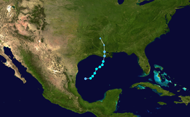
The storm turned to the northeast while moving around the periphery of a high pressure system over Texas, and attained a peak intensity of 45 mph (72 km/h) on October 9.
Strong wind shear limited further strengthening, and on October 10, Matthew struck Cocodrie, Louisiana as a minimal tropical storm.
While moving inland, Matthew spun off another low pressure system that formed over North Carolina on October 13.
[2] Initially, forecasters at the National Hurricane Center predicted that Matthew would take a more eastern track and hit the Florida Panhandle.
[3] Because the track shifted westward, the National Hurricane Center issued a Tropical Storm Warning from the Florida/Alabama border to Intracoastal City, Louisiana on the day before landfall.
[1] Though damage was minor throughout its path, Matthew dropped moderate to heavy rainfall across much of the Gulf Coast, peaking at over 15 inches (380 mm) in portions of Louisiana.
Matthew produced heavy rainfall across its path, totaling to 16.23 inches (412 mm) in Reserve in the southeastern portion of the state.
[1] Portions of northwestern Louisiana experienced significant rainfall, including a peak of 18 inches (460 mm) in Haynesville near the Louisiana/Arkansas border.
The beach erosion, which typically would have been minor for a weak storm, was greater than expected due to the passage of Hurricane Ivan just weeks before.
Tropical storm (39–73 mph, 63–118 km/h)
Category 1 (74–95 mph, 119–153 km/h)
Category 2 (96–110 mph, 154–177 km/h)
Category 3 (111–129 mph, 178–208 km/h)
Category 4 (130–156 mph, 209–251 km/h)
Category 5 (≥157 mph, ≥252 km/h)
Unknown

