Meteorological history of Hurricane Sandy
Performing a small loop over the central Caribbean Sea, the system intensified into a tropical storm a day later and became the final hurricane of the season before briefly coming ashore the coast of Jamaica on October 24.
An approaching trough over the central United States induced high wind shear over Sandy as it traversed the Bahamas, causing the hurricane to weaken to a tropical storm while turning more northeastward.
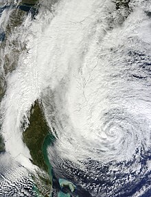
During this change in direction, Sandy began to transition into an extratropical cyclone, a process it completed before making landfall near Brigantine, New Jersey, late on October 29.
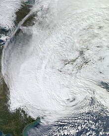
In addition to becoming the largest Atlantic hurricane, Sandy broke records for the lowest pressures ever observed in many cities across the Northeastern United States.
The origins of Hurricane Sandy trace back to a tropical wave that moved off the western coast of Africa and into the eastern Atlantic Ocean on October 11.
[2] On October 20, following modest organization, the National Hurricane Center (NHC) assessed a high potential for it to become a tropical cyclone within 48 hours,[3] tagging it "Invest 99L".
[6][7] By 1500 UTC on October 22, surface observations and satellite imagery indicated the system had developed enough organized convection to be classified as Tropical Depression Eighteen.
[8] Late on October 22, a Hurricane Hunters flight observed winds of 40 mph (64 km/h) in a rainband well removed from the center of circulation, prompting the NHC to upgrade the depression to Tropical Storm Sandy.
[11] Early on October 24, an eye began developing, as observed on microwave imagery, and Sandy was moving steadily northward, drawn by a trough approaching from the northwest.
[18] After exiting Cuba, a combination of dry air and increasing shear restricted the outflow of Sandy and caused the structure of the storm to become disorganized.
[20] By early October 26, a majority of the convection in association with Sandy was located to the north of the center, primarily due to wind shear and dry air to the southwest of the hurricane.
[21][22] As the day progressed, Sandy continued moving slowly to the north, and the strong wind shear caused the storm's intensity to decrease slightly.
[32] The storm revolved around an upper-level low over the eastern United States, and also to the southwest of a ridge over Atlantic Canada that the NHC described as "highly anomalous"; this caused Sandy to turn to the north and northwest.
[33] Maintaining an eye and deep convection, the hurricane intensified,[33] reaching a secondary peak of 100 mph (160 km/h) and an unusually low central barometric pressure of 940 millibars (28 inHg), by 1200 UTC on October 29;[1] at this time, the cyclone was moving over a small area of the Gulf Stream with waters in excess of 81 °F (27 °C).
[40] The remnants of Sandy brought heavy snow and high winds to the central Appalachian Mountains, resulting in blizzard warnings being issued.
[45] During the next two days, Sandy's remnants drifted northward and then northeastward over Ontario, before merging with another low pressure area over Eastern Canada, on November 2.
However, a storm surge of 13 feet, during low tide, was also reported at Battery Park during the 1821 Norfolk and Long Island hurricane, which occurred before records were officially kept.
[61] This typical pattern was blocked by a ridge of high pressure over Greenland, resulting in a negative Arctic oscillation, forming a kink in the jet stream and causing it to double back on itself off the East Coast; Sandy was caught up in this northwesterly flow.
[62] Noting that these blocking patterns are unusual in the fall but have been increasing, meteorologist Jeff Masters said that three studies in 2011 found "that the recent record decline in Arctic sea ice could be responsible, since this heats up the pole, altering the Equator-to-pole temperature difference, forcing the jet stream to slow down, meander, and get stuck in large loops.
[67] Meteorologist Kerry Emanuel stressed that no individual weather event, such as Hurricane Sandy, can be attributed to climate change, or any specific cause, for that matter.
[69] US Representative Henry Waxman, the top Democrat on the House Energy and Commerce Committee, wanted Republicans to hold a hearing on links between climate change and Hurricane Sandy.
"Hurricane Sandy is exactly the type of extreme weather event that climate scientists have said will become more frequent and more severe if we fail to reduce our carbon pollution.